2796337
Beschreibung

Mindmap von shenaii matlock, aktualisiert more than 1 year ago
|
|
Erstellt von shenaii matlock
vor etwa 9 Jahre
|
|
Skills for Geography
- Topographic Maps
- Area and grid Reference
- The vertical lines are called eastings
- This is stated first
- This is stated first
- Horizontial lines are called Northings
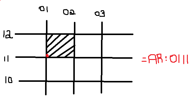
- Area Ref:
- Uses 4 digits
- the dot is in the bottom left corner
- Uses 4 digits
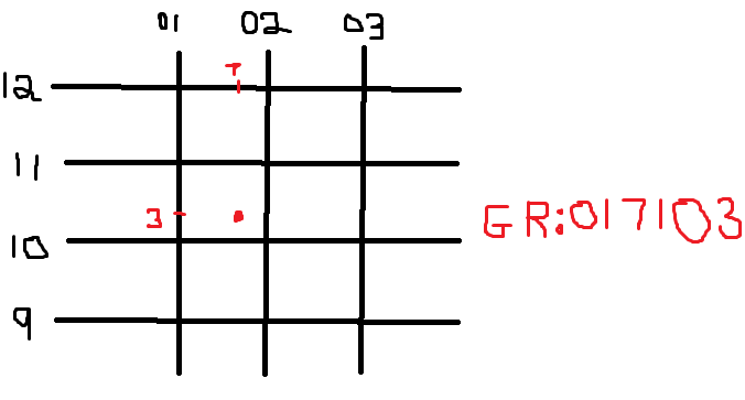
- Grid Reference
- Has 6 numbers
- the point is somewhere in the square
- Has 6 numbers
- The vertical lines are called eastings
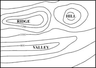
- Contour
- When the lines are closer together it means that there is a slop
- When the lines are far apart it means that it is a flat area
- Contour interval: is the value between the contour lines
- When lines are evenly spaces out then it is a constant slop
- When the lines are closer together it means that there is a slop
- Area and grid Reference
- Reading and interperating climate
graphs and weather maps
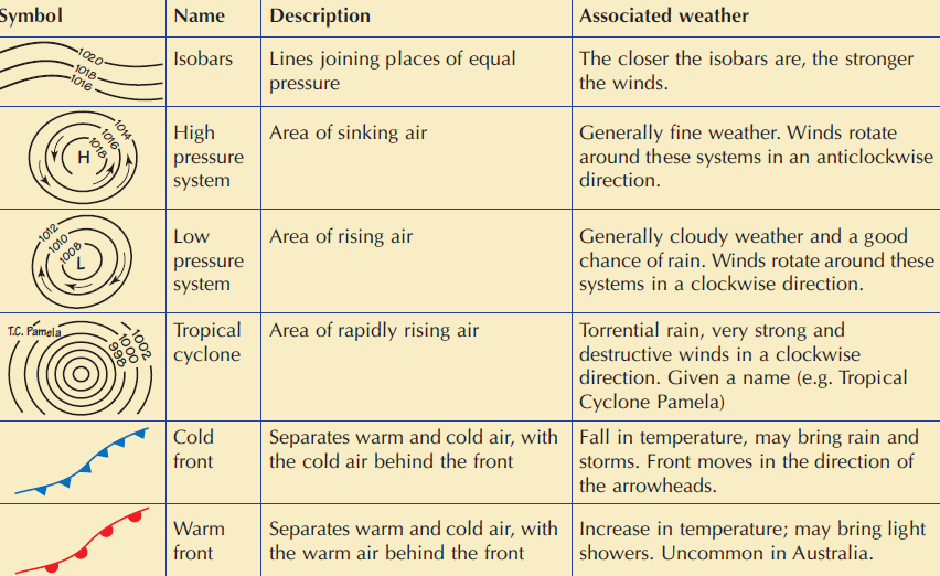
- Troughs and ridges
- A trough occures when an area of low pressure extends between 2 high
pressure systems. Often brings rain
- A ridge occures when a high pressure system is between 2 low pressure systems
- They are both marked by a dashed line on a synoptic chart
- A trough occures when an area of low pressure extends between 2 high
pressure systems. Often brings rain
- Rules for Climate statistic charts
- Rainfall on the left
- is a colume graph
- is a colume graph
- Temperature on the right
- Is on a line graph
- Plat the points in the middle of all the squares
- Join the Pints together in a smooth line
- Join the Pints together in a smooth line
- Plat the points in the middle of all the squares
- Is on a line graph
- Range
- To find the range subtract the smallest value
from the largest value
- To find the range subtract the smallest value
from the largest value
- Annual average rainfall
- Is the average rainfall for the year
- Add up all the average mothly rain together
- Is the average rainfall for the year
- To find the annual range
- Subtract the smallest value from the largest value from the moths
- Subtract the smallest value from the largest value from the moths
- Rainfall on the left
- Geography
Medienanhänge
Möchten Sie kostenlos Ihre eigenen Mindmaps mit GoConqr erstellen? Mehr erfahren.