Close

Label
Annotation
How to draw, label and annotate sketches
Aerial photographs
Oblique photograph
Satellite images
Atlas Maps
Ordnance Survey maps: Symbols
Ordnance Survey maps: Grid references
Ordnance survey maps: Measuring distances
Site
Situation
Shape
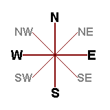
Compass directions

Cross sections
Patterns of human and physical features
Graphical skills: Bar charts
Graphical skills: Isolines
Graphical lines: Flow line maps
Geographical enquiry skills
ICT skills
Geographical Information System (GIS) skills
Advantages of GIS
Disadvantages of GIS
Uses of GIS

 Hide known cards