2991393
Descripción
Test por detatchment5, actualizado hace más de 1 año
|
|
Creado por detatchment5
hace más de 9 años
|
|
Pregunta 1
Pregunta
What does the term 'Intersection' mean?
Respuesta
-
The method of locating one's position on a map by determining the grid azimuth to at least two well-defined locations that can be pinpointed on the map.
-
The location of an unknown point by successively occupying at least two or more known positions on the ground and then map sighting on the unknown location.
-
Where two or more roads converge.
-
Finding the location of an unknown point by intersecting a major terrain feature with line shot on an azimuth from your location, then estimating distance.
Pregunta 2
Pregunta
There are _________ Mils in One Degree.
Respuesta
-
17.7
-
17,7
-
360.2
-
180
Pregunta 3
Pregunta
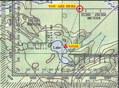
With the protractor’s edge aligned with the map GRID line and the center of the protractor aligned with your location; what azimuth in MILS do you travel to reach the lake? (write the number only)
Respuesta
-
3560
-
350
-
2700
Pregunta 4
Pregunta
With the protractor’s edge aligned with the map GRID line and the center of the protractor aligned with your location; what azimuth in DEGREES do you travel to reach the lake? (write the number only)
Respuesta
-
200
-
3560
-
Oh crap I don't know the answer
Pregunta 5
Pregunta
With regards to land navigation, the average steps it takes you to walk 100 meters is known as a _________.
Respuesta
-
Pace
-
Pace Count
-
Steps
-
Feet
Pregunta 6
Pregunta
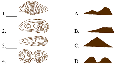
#4 on the left is a map representation of what letter graphic on the right?
Respuesta
-
A
-
B
-
C
-
D
Pregunta 7
Pregunta
#3 on the left is a map representation of what letter graphic on the right?
Respuesta
-
A
-
B
-
C
-
D
Pregunta 8
Pregunta
#2 on the left is a map representation of what letter graphic on the right?
Respuesta
-
A
-
B
-
C
-
D
Pregunta 9
Pregunta
#1 on the left is a map representation of what letter graphic on the right?
Respuesta
-
A
-
B
-
C
-
D
Pregunta 10
Pregunta
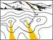
What minor terrain feature is highlighted by the yellow?
Respuesta
-
Spur
-
Draw
-
Hill
-
Cliff
Pregunta 11
Pregunta
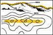
What Major Terrain Feature is depicted by the yellow?
Respuesta
-
Ridge
-
Mountain
-
Hills
-
Potholes
Pregunta 12
Pregunta
What is MGRS?
Respuesta
-
Military Grid Referencing Standard
-
Military Grid Reference System
-
Mil-Map Grid Referencing System
-
Map Grid Reference Sheet
Pregunta 13
Pregunta
How many mils are on a compass?
Respuesta
-
360 Mils
-
6400 Mils
-
3600 Mils
-
1 Million Mils
Pregunta 14
Pregunta
How many Norths are there on a map?
Respuesta
-
1
-
2
-
3
-
4
Pregunta 15
Pregunta
Out of the 7 basic colors of a map; what does the color Green identify?
Respuesta
-
Any and all vegetation would be indicated by green.
-
Where the clean energy is being produced.
-
INDFOR/GREENFOR (Such as ANA/ANP Forces)
-
Vegetation with military significance, such as woods, orchards, and vineyards
Pregunta 16
Pregunta
Assuming you are on an azimuth of 90 Degrees, what would your back azimuth be?
Respuesta
-
100 Degrees
-
81 Degrees
-
360 Degrees
-
270 Degrees
Pregunta 17
Pregunta
The United States utilizes UTM
Respuesta
- True
- False
Pregunta 18
Pregunta
Where would you find the Legend on a map?
Respuesta
-
Lower Left Margin
-
Lower Right Margin
-
Top of Map
-
Upper Right Margin
Pregunta 19
Pregunta
Linear features such as roads or highways, railroads, power transmission lines, ridge lines, or streams that run roughly parallel to your direction of travel are commonly known as what?
Respuesta
-
Nav Guide
-
Direct Navigational Aide
-
Handrail
-
Referencing features
Pregunta 20
Pregunta
UTM stands for Universal _________ Mercator
Respuesta
-
Timekeeping
-
Transverse
-
Tracking
-
Trolling
Pregunta 21
Pregunta
Indicates cultural (man-made) features such as buildings and roads, surveyed spot elevations, and all labels.
Respuesta
-
Black
-
Green
-
Red
Pregunta 22
Pregunta
The colors red and brown are combined to identify cultural features, all relief features, non-surveyed spot elevations, and elevation, such as contour lines on red-light readable maps.
Respuesta
- True
- False
Pregunta 23
Pregunta
Identifies hydrography or water features such as lakes, swamps, rivers, and drainage.
Respuesta
-
Blue
-
Green
-
Purple
Pregunta 24
Pregunta
Identifies vegetation with military significance, such as woods, orchards, and vineyards.
Respuesta
-
Orange
-
Green
-
Purple
Pregunta 25
Pregunta
Identifies all relief features and elevation, such as contours on older edition maps, and cultivated land on red-light readable maps.
Respuesta
-
Red
-
Brown
-
Black
-
Pink
Pregunta 26
Pregunta
The color Red classifies cultural features, such as populated areas, main roads, and boundaries, on older maps.
Respuesta
- True
- False
Pregunta 27
Pregunta
Occasionally other colors may be used to show special information. These are indicated in the marginal information as a rule.
Respuesta
- True
- False
¿Quieres crear tus propios Tests gratis con GoConqr? Más información.