5835498
Descripción
Test por tsampikos pompou, actualizado hace más de 1 año
|
|
Creado por tsampikos pompou
hace más de 8 años
|
|
Pregunta 1
Pregunta
58 Favourable conditions for a Cb cloud to develop are:
Respuesta
-
O a deep layer of very unstable moist next to the surface
-
O a shallow layer of very unstable moist air next to the surface
-
O a deep layer of very stable moist air next to the surface
-
O stable air up to 30000ft and very unstable above it
Pregunta 2
Pregunta
59 Relatively warmer dry air flows over a water body and absorbs water vapour. Then it becomes:
Respuesta
-
O less dense and rises
-
O more dense and more stable
-
O warmer and more stable
-
O saturated and its centre of mass descends
Pregunta 3
Pregunta
60 A cold, moist and unstable air mass arriving over north-west Europe could be:
Respuesta
-
O Polar maritime
-
O Tropical maritime
-
O Arctic continental
-
O Returning Tropical continental
Pregunta 4
Pregunta
61 Precipitation produced by St cloud is normally:
Respuesta
-
O Drizzle
-
O Shower of rain
-
O Shower of snow, given that above 10000 ft the ambient air temperature is negative
-
O Heavy rain
Pregunta 5
Pregunta
62 In a col:
Respuesta
-
O there are no standard weather phenomena
-
O strong surface winds are always expected
-
O heavy TS is the typical weather
-
O nothing of the aforementioned is true
Pregunta 6
Pregunta
63 An a/c is flying at constant indicated altitude, experiencing a permanent drift to the right. Given that the altimeter sub-scale has not been updated, the pilot expects:
Respuesta
-
O to fly at a progressively lower altitude than the indicated one
-
O to fly into radiation fog at the same altitude as the indicated altitude
-
O to fly at the same altitude as the indicated altitude
-
O to fly at a progressively higher altitude than the indicated one
Pregunta 7
Pregunta
64 Orographic lifting, when applied on an unstable air mass, normally will produce:
Respuesta
-
O cumuliform clouds
-
O stratiform clouds, mainly St
-
O lenticular clouds
-
O Cc clouds
Pregunta 8
Pregunta
65 Favourable conditions for the formation of advection fog are usually:
Respuesta
-
O a warm moist air mass cooled to below its dewpoint flowing over a much colder surface by light to moderate winds
-
O a cold moist air mass flowing across a much warmer surface by light to moderate winds
-
O moist air mass in contact with the ground, in light wind conditions on a cloudless night
-
O moist air mass in contact with the ground, in at least moderate wind conditions and intense sunshine
Pregunta 9
Pregunta
66 Within a warm sector of a depression we would normally expect:
Respuesta
-
O Poor visibility both above and below extensive stratiform clouds
-
O Good visibility above and below extensive stratiform clouds
-
O Good visibility below BKN heap clouds
-
O Poor visibility above Ns cloud but moderate to good visibility below
Pregunta 10
Pregunta
67 Carburettor icing is possible, under certain conditions, in ambient air temperature as high as:
Respuesta
-
O +30 °C
-
O +5 °C
-
O +10 °C
-
O +20 °C
Pregunta 11
Pregunta
68 Etesian is:
Respuesta
-
O the name of winds of generally north direction over the Aegean from May to early October
-
O a strong cold N or NW wind which blows into the Gulf of Lions in the NW Mediterranean
-
O a local wind over the eastern shores of Adriatic
-
O a hot wind blowing northwards from Africa to the Mediterranean
Pregunta 12
Pregunta
69 The term CAVOK in a TAF or METAR implies:
Respuesta
-
O visibility >=10km and no cloud below 5000ft, given that the minimum sector altitude is not a determining factor
-
O visibility >=10km and less than SCT clouds below 5000ft
-
O visibility >=10nm and no cloud below 5000ft, given that the minimum sector altitude is not a determining factor
-
O visibility >=10nm and clear sky
Pregunta 13
Pregunta
70 A VOLMET is defined as:
Respuesta
-
O a continuous radio broadcast of selected aerodromes' actual weather observations and forecasts
-
O a radio transmission of a requested aerodrome actual weather observation and forecast
-
O a continuous telephone message of selected aerodrome TAFs
-
O a radio broadcast of selected aerodromes' forecasts
Pregunta 14
Pregunta
71 The weather group +SHSNRA in a TAF implies:
Respuesta
-
O heavy showers of snow and rain
-
O slight showers of snow and rain
-
O slight showers of snow becoming rain close to the surface
-
O heavy showers of snow becoming rain close to the surface
Pregunta 15
Pregunta
72 The following is true for a quasi-stationary front:
Respuesta
-
O all the other answers are true
-
O it is almost stationary
-
O sometimes it is actually stationary
-
O its position appears almost unchanged in successive synoptic charts
Pregunta 16
Pregunta
73 Usually the speed of a warm front is:
Respuesta
-
O 2/3 of that of a cold front
-
O 1/4 of that of a cold front
-
O 1/3 of that of a cold front
-
O 1/5 of that of a cold front
Pregunta 17
Pregunta
74 The symbol below appearing on a Significant Weather Chart means:
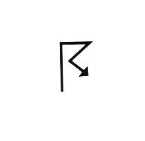
Respuesta
-
O thunderstorms
-
O moderate icing
-
O moderate turbulence
-
O fog patches
Pregunta 18
Pregunta
75 The correct decoding of the section «BECMG FM 1200 + RASH» in a METAR would be:
Respuesta
-
O becoming from 1200 UTC heavy rain showers
-
O from 1200 UTC heavy rain will commence
-
O from 1200 UTC the prevailing rain, gradually will become sleet
-
O visibility due to rain and snow will be reduced to 1200 m (fm value)
Pregunta 19
Pregunta
76 The symbol below appearing on a Significant Weather Chart means:
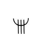
Respuesta
-
O moderate icing
-
O moderate turbulence
-
O thunderstorms
-
O fog patches
Pregunta 20
Pregunta
77 The several coloured rings around the sun or moon, known as a Halo, suggest the presence of :
Respuesta
-
O High clouds
-
O Low clouds
-
O Medium clouds
-
O Heap clouds
Pregunta 21
Pregunta
78 A low level inversion has caused a mist layer, which reduces severely the forward visibility to see the surface. Given that the a/c is flying approximately at 2000ft, what do you suggest the pilot to do, to improve his view of the ground ahead of the a/c:
Respuesta
-
O fly higher
-
O fly lower
-
O fly pitching down
-
O fly exactly at the top of the mist layer
Pregunta 22
Pregunta
79 The term TEMPO in a TAF is interpreted as:
Respuesta
-
O temporary fluctuations that will last for less than an hour and in aggregate less than half of the period indicated
-
O temporary fluctuations lasting less than an hour and in aggregate more than half of the period indicated
-
O temporarily the phenomena described in the sequel will become more intense
-
O a temporary variation to the main forecast lasting for less than half of the forecast period
Pregunta 23
Pregunta
80 At 4000ft AMSL the temperature is +2°C. Compared with the International Standard Atmosphere (ISA) temperature at the same position, it is:
Respuesta
-
O ISA-5
-
O ISA+5
-
O ISA+8
-
O ISA-8
Pregunta 24
Pregunta
81 In a barometric Low, when warmer air replaces cold air at the surface we have a:
Respuesta
-
O warm front, whose slope is normally 1:150
-
O cold front, whose slope is normally 1:150
-
O cold front, whose slope is normally 1:50
-
O warm front, whose slope is normally 1:50
Pregunta 25
Pregunta
82 During the dissipating stage of a thunderstorm cloud the downdrafts become:
Respuesta
-
O most prevalent
-
O weaker
-
O less in number
-
O vanishing
¿Quieres crear tus propios Tests gratis con GoConqr? Más información.