5866052
Descripción
Test por tsampikos pompou, actualizado hace más de 1 año
|
|
Creado por tsampikos pompou
hace más de 8 años
|
|
Pregunta 1
Pregunta
1 In cold air, the rate of reduction of the barometric pressure as height AGL increases is:
Respuesta
-
O higher than in warm air.
-
O the same as in warm air.
-
O less than in warm air.
-
O there is no rule.
Pregunta 2
Pregunta
18 Which element of a frontal system arrives first at a place towards to it moves?
Respuesta
-
O the Warm front
-
O the Warm sector
-
O the Cold front
-
O depends on ground temperature
Pregunta 3
Pregunta
24 Which of the following is issued every half an hour and provides a TREND type forecast:
Respuesta
-
O METAR
-
O SPECI
-
O ATIS
-
O TAF
Pregunta 4
Pregunta
27 Stratiform clouds are characteristic of:
Respuesta
-
O a Warm front.
-
O a Cold front.
-
O an Occluded front.
-
O a Cold and an Occluded front.
Pregunta 5
Pregunta
32 What surface weather is associated with a stationary high pressure area over land in the winter?
Respuesta
-
O possible fog and low St clouds
-
O thunderstorms
-
O continuous rain from Ns and Ac clouds
-
O snow showers
Pregunta 6
Pregunta
35 What kind of meteorological message is the following?
IN ATHINAI FIR EMBD TS OBS IN WEST PART MOV E-NE INTSF=
Respuesta
-
O SIGMET
-
O METAR
-
O TAF
-
O GAFOR
Pregunta 7
Pregunta
36 What kind of meteorological message is the following?
FT LGRX 201600Z 210018 VRB05KT 5000 FEW025 SCT030 TEMPO 0206 3000 BECMG 1218 +RA BKN020
Respuesta
-
O TAF
-
O METAR
-
O SIGMET
-
O GAFOR
Pregunta 8
Pregunta
64 Orographic lifting, when applied on an unstable air mass, normally will produce:
Respuesta
-
O cumuliform clouds
-
O stratiform clouds, mainly St
-
O lenticular clouds
-
O Cc clouds
Pregunta 9
Pregunta
80 At 4000ft AMSL the temperature is +2°C. Compared with the International Standard Atmosphere (ISA) temperature at the same position, it is:
Respuesta
-
O ISA-5
-
O ISA+5
-
O ISA+8
-
O ISA-8
Pregunta 10
Pregunta
81 In a barometric Low, when warmer air replaces cold air at the surface we have a:
Respuesta
-
O warm front, whose slope is normally 1:150
-
O cold front, whose slope is normally 1:150
-
O cold front, whose slope is normally 1:50
-
O warm front, whose slope is normally 1:50
Pregunta 11
Pregunta
84 Hazards to aviation due to the presence of Cb cloud could be experienced:
Respuesta
-
O inside, over or under the cloud and when the a/c is within 10nm from the cloud
-
O inside, over or under the cloud only
-
O inside the cloud only
-
O inside, over or under the cloud and when the a/c is between 10nm to 100nm from the cloud
Pregunta 12
Pregunta
93 Given the Significant Weather Chart in Fig. 13,in the area of Ionion sea is shown
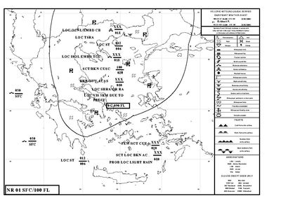
Respuesta
-
O Turbulence
-
O Icing
-
O Fog
-
O Drizzle
Pregunta 13
Pregunta
94 In the lower part of the stratosphere the temperaturefrom the
Respuesta
-
O is almost constant
-
O decreases with altitude
-
O increases with altitude
-
O increases at first and decreases afterward
Pregunta 14
Pregunta
96 Dew point is defined as
Respuesta
-
O the temperature to which moist air must be cooled to become saturated at a given pressure
-
O the lowest temperature at which evaporation will occur for a given pressure
-
O the temperature below which the change of state in a given volume of air will result in the absorption of latent heat
-
O the lowest temperature to which air must be cooled in order to reduce the relative humidity
Pregunta 15
Pregunta
107 Which type of fog is likely to form when air having temperature of 15°C and dew point of 12°C blows at 10 knots over a sea surface having temperatures of 5°C ?
Respuesta
-
O Advection fog
-
O Frontal fog
-
O Steam fog
-
O Radiation fog
Pregunta 16
Pregunta
108 Precipitation in the form of showers occurs from
Respuesta
-
O convective clouds
-
O stratified clouds
-
O cirro-type clouds
-
O clouds containing only ice crystals
Pregunta 17
Pregunta
111 Which in-flight hazard is most commonly associated with warm fronts?
Respuesta
-
O Precipitation-induced fog.
-
O Advection fog.
-
O Radiation fog.
-
O Steam fog
Pregunta 18
Pregunta
112 In which environment is aircraft structural ice most likely to have the highest accumulation rate?
Respuesta
-
O Freezing rain.
-
O Cumulus clouds with below freezing tempera¬tures.
-
O Freezing drizzle.
-
O None of the those
Pregunta 19
Pregunta
113 In what ways do advection fog, radiation fog, and steam fog differ in their formation or location?
Respuesta
-
O Radiation fog is restricted to land areas; advection fog is most common along coastal areas; steam fog forms over a water surface.
-
O Advection fog deepens as windspeed increases up to 20 knots; steam fog requires calm or very light wind; radiation fog forms when the ground or water cools the air by radiation.
-
O Steam fog forms from moist air moving over a colder surface; advection fog requires cold air over a warmer surface; radiation fog is produced by radiational cooling of the ground.
-
O None of the those
Pregunta 20
Pregunta
114 . Which conditions are favorable for the formation of a surface based temperature inversion?
Respuesta
-
O Clear, cool nights with calm or light wind,
-
O Area of unstable air rapidly transferring heat from the surface.
-
O Broad areas of cumulus clouds with smooth, level bases at the same altitude
-
O Advection of warm moist air
Pregunta 21
Pregunta
118 . What type weather can one expect from moist, unstable air, and very warm surface temperature?
Respuesta
-
O Strong updrafts and cumulonimbus clouds.
-
O Fog and low stratus clouds.
-
O Continuous heavy precipitation
-
O Fair weather and cirrus clouds
Pregunta 22
Pregunta
120 . If clouds form as a result of very stable, moist air being forced to ascend a mountain slope, the clouds will be
Respuesta
-
O stratus type with little vertical development and little or no turbulence.
-
O cirrus type with no vertical development or turbulence
-
O cumulus type with considerable vertical development and turbulence.
-
O rotor type
Pregunta 23
Pregunta
121 The formation of either predominantly stratiform or predominantly curnuliform clouds is dependent upon the
Respuesta
-
O stability of the air being lifted.
-
O source of lift
-
O temperature of the air being lifted.
-
O the difference between surface temperature and due point
Pregunta 24
Pregunta
137 Which statement is true regarding squall lines?
Respuesta
-
O They are nonfrontal and often contain severe, steady-state thunderstorms.
-
O They are always associated with cold fronts.
-
O They are slow in forming, but rapid in movement.
-
O None of the those
Pregunta 25
Pregunta
141 The conditions most favorable to wave formation over mountainous areas [Fig.40], are a layer of
Respuesta
-
O stable air at mountaintop altitude and a wind of at least 20 knots blowing across the ridge.
-
O unstable air at mountaintop altitude and a wind of at least 20 knots blowing across the ridge
-
O moist, unstable air at mountaintop altitude and a wind of less than 5 knots blowing across the ridge.
-
O None of those
Pregunta 26
Pregunta
142 During departure, under conditions of suspected low-level wind shear, a sudden decrease in headwind will cause
Respuesta
-
O a loss in airspeed equal to the decrease in wind velocity.
-
O a gain in airspeed equal to the decrease in wind velocity.
-
O no change in airspeed, but groundspeed will decrease.
-
O stalling
Pregunta 27
Pregunta
145 . If a temperature inversion is encountered immediately after takeoff or during an approach to a landing, a potential hazard exists due to
Respuesta
-
O wind shear.
-
O strong surface winds.
-
O strong convective currents.
-
O low visibility
Pregunta 28
Pregunta
147 . The station originating the following METAR observation has a field elevation of 3,500 feet MSL If the sky cover is one continuous layer, what is the thickness of the cloud layer? (Top of overcast reported at 7,500 feet MSL)
METAR LGTP 151250Z 17006KT 4000 OVC005 13/11 A2998
Respuesta
-
O 3,500 feet.
-
O 2,500 feet.
-
O 4,000 feet.
-
O 3000 feet
Pregunta 29
Pregunta
154 What does the contraction VRB in the Terminal Aerodrome Forecast (TAF) mean?
Respuesta
-
O Wind direction is variable.
-
O Wind speed is variable throughout the period.
-
O Cloud base is variable.
-
O Visibility is variable
Pregunta 30
Pregunta
155 Terminal Aerodrome Forecasts (TAF) are issued how many times a day and cover what period of time?
Respuesta
-
O Eight times daily and are usually valid for a 9 hour period.
-
O Six times daily and are usually valid for a 12 hour period including a 4-hour categorical outlook.
-
O Six times daily and are valid for 9 hours including a 6-hour categorical outlook.
-
O Five times daily and are valid for a 6 hours period
¿Quieres crear tus propios Tests gratis con GoConqr? Más información.