8957319
Descripción
Test por Monty Leaman, actualizado hace más de 1 año
|
|
Creado por Monty Leaman
hace más de 7 años
|
|
Pregunta 1
Pregunta
Which of the following is not a subcomponent of the Earth system
Respuesta
-
Cryosphere
-
Atmosphere
-
Hydrosphere
-
Geosphere
-
Biosphere
-
Lithosphere
-
Asthenosphere
Pregunta 2
Pregunta
An open system has an exchange of ...
Respuesta
-
Nothing
-
Energy
-
Energy and matter
Pregunta 3
Pregunta
Which one of the following is not a characteristic of Systems?
Respuesta
-
Can be found on different scales
-
Have limits
-
Are associated with processes
-
Energy cant be created or destroyed, and transfer is never 100%
Pregunta 4
Pregunta
What term describes 'where similar states of the system can be achieved in different ways'
Respuesta
-
Dynamic equilibrium
-
Quasi equilibrium
-
Equifinality
-
Feedback
-
Relaxation time
-
Threshold
Pregunta 5
Pregunta
What term describes 'where a system is regulated by intensifying (positive) or opposing (negative) the direction of the system'
Respuesta
-
Dynamic equilibrium
-
Quasi equilibrium
-
Equifinality
-
Feedback
-
Relaxation time
-
Threshold
Pregunta 6
Pregunta
Which of the following is the definition for 'relaxation time'?
Respuesta
-
The time taken to reach equilibrium during the change form one equilibrium state to another
-
The transition from one state to the system to another
Pregunta 7
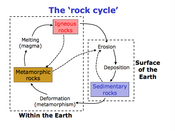
Pregunta
What minerals are dominant components of most rocks (Felsic- e.g. Quartz, Mafic- iron and magnesium rich- heavier and darker)?
Respuesta
-
Graphine
-
Graphite
-
Silicone
-
Silicates
Pregunta 8
Pregunta
Silicate rocks make up what percentage of all rocks world wide?
Respuesta
-
70%
-
80%
-
90%
-
100%
Pregunta 9
Pregunta
Extrusive igneous rocks cool slowly and form a large crystalline structure
Respuesta
-
False
-
True
Pregunta 10
Pregunta
Contact metamorphism (as opposed to regional and dynamic metamorphism) occurs in the presence of what?
Respuesta
-
Extreme heat from magma
-
Extreme pressure from tectonic plates
-
Both heat (magma) and pressure (tectonic plates)
Pregunta 11
Pregunta
Which rock type is formed by geomorphological processes on the earths surface (including: rivers, coasts, deep seas, lakes, mountain sides and deserts)?
Respuesta
-
Sedimentary (clastic and chemical)
-
Igneous (intrusive and extrusive)
-
Metamorphic (contact, regional and dynamic)
Pregunta 12
Respuesta
-
Yes
-
No
Pregunta 13
Pregunta
Which of the following is not a method by which we measure geological time?
Respuesta
-
Absolute (radiometric) dating
-
Relative age dating
-
Analysis of ice cores
Pregunta 14
Pregunta
Which of the following is not a principle of relative age dating?
Respuesta
-
Super-positioning
-
Horizontality
-
Crosscutting
-
Inclusion
-
Faunal succession
-
Geological lapping
Pregunta 15
Pregunta
How long ago was the Earth formed?
Respuesta
-
4.1 Ga
-
4.2 Ga
-
4.3 Ga
-
4.4 Ga
-
4.5 Ga
Pregunta 16
Pregunta
How do we know the internal structure of the Earth (lithosphere, upper and lower mantle, outer and inner core)?
Respuesta
-
Direct sampling
-
Indirect sampling
-
Seismic methods
-
All of the above
Pregunta 17
Pregunta
Which seismic wave is transverse and travels slower (and also has 103-180 degree shadow when used to identify the layers of the earth because it cannot travel through the solid core)
Respuesta
-
S-waves
-
P-waves
Pregunta 18
Pregunta
The lithosphere is comprised of the continental/oceanic crust, moho and upper mantle
Respuesta
-
True
-
Flase
Pregunta 19
Pregunta
The mantle is comprised of the lithospheric mantle and asthenosphere
Respuesta
-
True
-
False
Pregunta 20
Pregunta
Travel times from seismic waves help to tell us about the internal structure of the earth (changes in wave velocity reflect the rheology and composition of the crust, mantle and core)
Respuesta
-
True
-
Flase
Pregunta 21
Pregunta
The density and flow of material in the mantle and core is uniform
Respuesta
-
False
-
True
Pregunta 22
Pregunta
What crust is underlain by sharp Moho, comprised of young igneous rocks (max 180 Ma) and is a 5-7km thick layered structure
Respuesta
-
Oceanic crust
-
Continental crust
Pregunta 23
Pregunta
Side-to-side movements of plates along fault is known as what?
Respuesta
-
Right/left lateral faults
-
Dip slip faults
-
Stick slip faults (elastic rebound)
Pregunta 24
Pregunta
The Richter magnitude scale of measuring earthquakes uses seismometers to measure the earthquake and then processes the figure and places it on a logarithmic scale
Respuesta
-
True
-
False
Pregunta 25
Pregunta
Foreshocks, main shock and aftershocks can all be measured using a seismometer
Respuesta
-
True
-
False
Pregunta 26
Pregunta
Earthquakes occur at which plate boundaries?
Respuesta
-
Conservative and constructive
-
Conservative and destructive
-
Constructive and destructive
-
Only conservative
-
At all plate boundaries
Pregunta 27
Pregunta
What were the principles of Geosyncline Theory?
Respuesta
-
Deepening and filling of basins were caused by crustal contraction and the Earth's heat crushed and folded land forming mountain chains
-
Considered all continents drifted away from a single large landmass; ideas largely dismissed by scientific community until late 1950s
Pregunta 28
Pregunta
Which of the following provides evidence for continental drift?
Respuesta
-
Continental fit
-
Geological fit
-
Tectonic fit
-
Palaeoclimatic evidence
-
Palaeontological evidence
-
All of the above
Pregunta 29
Pregunta
Which of the following evidence for continental drift was not available to Alfred Lothar Wegener when he came up with his theorem that all the continents drifted away from a single large landmass?
Respuesta
-
Continental fit
-
Geological fit
-
Tectonic fit
-
Palaeoclimatic evidence
-
Palaeontological evidence
-
Paleaomagnetic evidence
Pregunta 30
Pregunta
With regards to the theory that all the continents drifted away from a single land mass; the fact that plant and reptile species are similar in continents that are now separated by oceans suggests that these continents must have at some point been connected to allow for this movement, is classed under which of the following categories?
Respuesta
-
Palaeoclimatic evidence
-
Palaeontological evidence
-
Tectonic evidence
Pregunta 31
Pregunta
What mechanism did Wegener suggest was responsible for the drifting of continents?
Respuesta
-
Continents moved through oceanic crust, like an icebreaker
-
Thermal convection currents in the mantle moved the continents
-
Magnetic field of the earth caused the (magnetic) continental crust to move
Pregunta 32
Pregunta
Atoms in minerals and rocks align to the Earth's dipole, only when heat is present. Given this information, which of the following statements is false?
Respuesta
-
Thermoremnant magnetisation: when the high temperature of the material (magma) allows the atoms to align to the same magnetic direction as the Earth's dipole with ease
-
Detrital remnant magnetisation: when magma cools (igneous rock) its atoms might align to the same direction as the Earth's dipole, at that time because the temperature is suffice to allow for realignment
-
Chemical remnant magnetisation: during a chemical reaction, heat might be given out, and atoms can realign to the Earth's dipole at that time
-
The magnetic dipole of the Earth is fixed throughout time and atomic dipoles are only induced when there is sufficient heat
Pregunta 33
Pregunta
Apparent polar wander paths are useful because...
Respuesta
-
They provide evidence for continental drift
-
Enables rocks in different areas to be correlated with each other
-
Can explain presence of rock types, that were formed in different climates, in the same area
-
All of the above
Pregunta 34
Pregunta
The magnetic pole is fixed. Apparent polar wander paths uses the model of it 'wondering' to enable recordings of changes in declination of the land; thereby, all continents have their own apparent polar wondering path
Respuesta
-
True
-
False
Pregunta 35
Pregunta
Sea floor spreading is a process thereby new oceanic crust forms at an oceanic ridge due to volcanic activity, and gradually moves away from the ridge. This theory from Harry Hammond Hess can help explain what?
Respuesta
-
How the continents could actually move- mechanism
-
Enabled us to record the Earth's dipole through time because horizontal strips preserve the dipole of Earth over specific time period
-
Both of the above
Pregunta 36
Pregunta
Who proposed mantel convection?
Respuesta
-
Holmes
-
Wilson
-
Wegener
Pregunta 37
Pregunta
What is currently believed to be the main driver of plate movement?
Respuesta
-
Convection currents in the mantle
-
Ridge push and slab pull
Pregunta 38
Pregunta
What did Tuzo-Wilson propose, in 1963, to explain how volcanic activity can occur away from plate boundaries (such as Hawaii)
Respuesta
-
Hotspot and plume theory
-
Continental drift
-
Apparent polar wondering paths
-
Sea-floor spreading
Pregunta 39
Pregunta
What creates island chains like Hawaii?
Respuesta
-
Extension that permits rise of partial melt from the asthenosphere
-
Mantle plumes that convectively bring unusually hot mantle from the core-mantle boundary
-
There is a debate over which one is true (perhaps both are factors)
Pregunta 40
Pregunta
The magnetic field vector is parallel to the Earth's surface in equatorial regions and becomes progressively more steeply inclined towards the polar regions; therefore, if rocks preserve the orientation of magnetic field vector at the time of their formation, and can be dated, the latitude at which they formed can be inferred
Respuesta
-
True
-
False
Pregunta 41
Pregunta
In hot magma, the dipoles change orientation rapidly, so magma can have permanent magnetisation
Respuesta
-
False
-
True
Pregunta 42
Pregunta
Why do volcanoes erupt?
Respuesta
-
Due to magma buoyancy: the hot magma is less dense that the crustal rock and therefore is rises to the surface; heat source is from radioactive decay, mantle convection and residual from cooling of the earth
-
Gases (volatiles): come out of solution at shallow depths and decrease the density of magma allowing it to rise faster; bubble formation is called vesiculation. Bubbles can join up and become a stream of gas with blobs of magma in it- called fragmentation.
-
Gases (volatiles) can get trapped in the viscous magma, this speeds up flow towards the surface (increases pressure) and paid expansion at the vent causes an explosive eruption
-
Magma recharge is required to keep feeding a volcanic eruption/magma chamber
-
All of the answers in combination cause volcanoes to erupt
Pregunta 43
Pregunta
Where are volcanoes found?
Respuesta
-
Subduction zones- shield thin [basalt] volcanoes (effusive)
-
Intra-plate hotspots
-
Destructive plate boundaries- composite thick felsic [rhyolite] volcanos (explosive)
-
At all of the above
Pregunta 44
Pregunta
Which of the following definitions id incorrect?
Respuesta
-
Magmatic - related to magma or magmatic gases; classification dependent on explosivity and column height or type-behaviour
-
Hydrovolcanic - eruptions generated by heating of water external to magma
-
Phreatic - dry-land steam blast eruptions, no magma erupted
-
Phreatomagmatic - partially hydrovolcanic and partially phreatic
Pregunta 45
Pregunta
The collapse of a lava dome (which is formed by viscous magma erupted effusively) can cause extremely dangerous pyroclastic flow
Respuesta
-
True
-
False
Pregunta 46
Pregunta
Which of the following is not the particle name and size for materials present in pyroclastic flow?
Respuesta
-
Blocks/bombs| over 64mm
-
Lapilli | under 64 mm
-
Volcanic ash | under 2 mm
-
Volcanic dust | under 0.063 mm
-
Volcanic micro-cloud | under 0.000064 mm
Pregunta 47
Pregunta
Which of the following is the definition of pyroclastic surge (and not pyroclastic flow)?
Respuesta
-
A more energetic and dilute mixture of searing gas and rock fragments. Move easily up and over ridges; flows ten to follow valleys
-
High-speed avalanches of hot ash, rock fragments, and gas move down the sides of volcano during explosive eruptions or when the steep edge of a dome breaks apart and collapses. Can reach over 800 degrees and move at 100-150 mph
Pregunta 48
Pregunta
Fill in the blank: Higher silicone dioxide content (thus viscosity and ability to trap gas) and contact with water '...' explosivity
Respuesta
-
Increase
-
Decrease
-
Do not effect
Pregunta 49
Pregunta
Traditional names from classic eruptions are used to describe other eruptions and volcano forms. The problem with this is...?
Respuesta
-
They poorly define volcanoes and are subjective
-
It measures the height of eruption column and degree of explosivity
Pregunta 50
Pregunta
Postglacial volcanism in Iceland is dominated by which type of rock (lava)
Respuesta
-
Silicic
-
Intermediate
-
Basaltic
Pregunta 51
Pregunta
Prediction of future volcanic activity is simple and unchallenging
Respuesta
-
False
-
True
Pregunta 52
Pregunta
The Tibetan Plateau is an umbrella term for mountain chains including: Karakoram Mountains, Hindu Kush and Tien Shan | generally 4,000-5,000m
Respuesta
-
True
-
False
Pregunta 53
Pregunta
How was the Tibetan Plateau formed?
Respuesta
-
By continental collision (destructive plate boundary) when the Indian plate moved northwards into the Eurasian plate
-
By continental collision (on a transition plate boundary) when the Indian plate formed a dip fault with the Eurasian plate
Pregunta 54
Pregunta
The Tibetan Plateau is 5% of the Earth's land area but produces what percentage of total river sediment load?
Respuesta
-
10%
-
25%
-
40%
-
55%
Pregunta 55
Pregunta
Which of the following are features of the Tibetan Plateau's geomorphology?
Respuesta
-
Land uplift and creation of relief- encouraged high chemical/physical weathering and river downcutting
-
Sediment fills of more than 3km thick gravels deposited in fault-controlled sedimentary basins
-
Drainage pattern of the Brahmaputra river - drainage was diverted by rising mountains
-
All of these
Pregunta 56
Pregunta
The Tibetan Plateau casts a rain shadow on central Asia, as it's uplift acts as a topographic barrier preventing monsoons from reaching central Asia
Respuesta
-
True
-
False
Pregunta 57
Pregunta
Winter monsoon winds blowing NW to SE transport fine sediment to central china (because summers are dry due to uplift of Tibetan Plateau) - resulting in depositions of 'loess'
Respuesta
-
True
-
False
Pregunta 58
Pregunta
What is 'loess'
Respuesta
-
Wind blown silt deposits, yellow to grey in colour, grains are angular, sediment comprises of: quartz, feldspar, mica and clay minerals bound together with a calcareous cement
-
Region immediately south east of the Tibetan Plateau
Pregunta 59
Pregunta
How are silt-sized particles produced (in Loess)?
Respuesta
-
Mechanical weathering of metamorphic rocks
-
Chemical weathering of metamorphic rocks
-
Glacial grinding
-
Frost action
-
Fluvial erosion
-
All of the above
Pregunta 60
Pregunta
Loess covers what percentage of the Earth's land surface (mainly in periglacial areas, continental interiors, associated with major rivers and mountain ranges)?
Respuesta
-
0-5%
-
5-10%
-
10-15%
Pregunta 61
Pregunta
Which one of the following is correct with regards to Loess records?
Respuesta
-
Strong winter monsoon = coarser sediments, higher sedimentation rates
-
Strong winter monsoon = finer sediments, lower sedimentation rates
-
Loess sequences contain buried soils (palaeosols), these sequences can't be dated and are, therefore, not used in geomagnetic polarity
Pregunta 62
Pregunta
What term is used to illustrate the significance of the Tibetan Plateau- because it is the source of 10 major river systems that provide irrigation, power and drinking water for over 1.3 billion people in Asia?
Respuesta
-
The third pole
-
The major source
-
Asia's north pole
-
Danny Driver
Pregunta 63
Pregunta
The Tibetan Plateau has shown now effects of climate change
Respuesta
-
False
-
True
Pregunta 64
Pregunta
Which of the following is the definition of weathering (the other is the definition of erosion)?
Respuesta
-
Processes of the breakdown of rocks and minerals in situ (in place)
-
Process of breakdown of rocks and minerals and the transport of the products
Pregunta 65
Pregunta
Which of the following are internal forces acting on a rock?
Respuesta
-
Heating, cooling, chemical reactions, circulation of air/water (weathering)
-
Loading and interaction with the outside environment (erosion)
Pregunta 66
Pregunta
Which one of the following the definition of 'stress' with regards to weathering (the other is strength)
Respuesta
-
Forces that act to pull a rock apart- tensile (cracking), compressive (squashing), shear (sliding) plus gravity
-
Forces that act to keep a rock together- atomic, chemical, cohesion and friction
Pregunta 67
Pregunta
What is physical weathering?
Respuesta
-
Where rocks break down into smaller compenents by mechanical processes (e.g. pressure, temperature, ice salt crystal growth; frost shattering, granular disintegration, exfoliation)
-
Break down of chemical bonds holding rocks together, or a process that causes changes in the composition of minerals within rocks (solution, hydrolysis, oxidation and reduction, carbonation plus biological processes- enhance chemical weathering by production of organic acids
Pregunta 68
Pregunta
Physical weathering is more likely to occur at lower temperatures and lower precipitation rates
Respuesta
-
True
-
False
Pregunta 69
Pregunta
Limestone is chemically weathered via carbonation and this dissolution can create distinctive karstic topographies and river drainage patterns
Respuesta
-
True
-
Flase
Pregunta 70
Pregunta
Mechanics of airflow are similar to water-flow, but different fluid densities (viscosity)
Respuesta
-
True
-
False
Pregunta 71
Pregunta
Which of the following is true for the comparison between air and water?
Respuesta
-
For a given sediment grain size, air needs to be travelling more quickly than water in order to facilitate transport
-
Air is more efficient at sediment sorting than water
-
Airflow is affected by air temperature (cold air is able to carry sediment more easily than warm air because it is more dense)
-
All of the above
Pregunta 72
Pregunta
Which of the following is true for a high pressure system in deserts?
Respuesta
-
Descending air, low precipitation, low vegetation and high chemical/mechanical weathering
-
Ascending air, low precipitation, low vegetation and low chemical/mechanical weathering
Pregunta 73
Pregunta
Loess deposits in... (i.e. not dust transport)
Respuesta
-
Cold deserts
-
Hot deserts
Pregunta 74
Pregunta
What is deflation (the other is threshold velocity)?
Respuesta
-
General term describing all the processes by which sediment is moved by wind
-
Minimum wind speed needed to move a sediment grain of a certain size
Pregunta 75
Pregunta
Which of the following is impact threshold (the other is fluid threshold)?
Respuesta
-
The minimum wind speed needed to move a particular grain that is already in motion
-
The minimum wind speed needed to move a particular grain that is stationary
Pregunta 76
Pregunta
Which of the following does not influence sediment transport in air?
Respuesta
-
Wind speed
-
Wind direction
-
Sediment availability
-
Vegetation cover
-
Temperature
-
Carbon dioxide concentrations
Pregunta 77
Pregunta
What is an erosional landform (examples include: lag gravels, ventifacts, yardangs, deflation hollows)?
Respuesta
-
Where capacity for transport is lower than sediment supply
-
Where capacity for transport is higher than supply
Pregunta 78
Pregunta
Wind erosion causes an accumulation of large pebbles in deposit site, creating a desert pavement
Respuesta
-
True
-
False
Pregunta 79
Pregunta
Which of the following statements is not true?
Respuesta
-
Sand dune size increases in this order: ripples, dunes, mega-dunes, sand seas)
-
Dunes may be superimposed on one another
-
Dunes are always fixed (stable) and never free (unstable)
-
Dunes can be active at the present time or relict (inactive)
-
Presence or size of dunes can indicate climate changes
Pregunta 80
Pregunta
What type of sand dune is this and under what conditions does it form?
Respuesta
-
Barchan dune (flat landscape, one direction wind, little or no vegetation, limited sand supply
-
Longitudinal dune (when barchan dunes join together and form ridges perpendicular to the wind direction; sand supply is abundant)
-
Star dunes (controls include wind strength, vegetation cover and sediment supply- this controls all dunes)
-
Parabolic dune (strong winds erode section of vegetated sand a.k.a. blowout- vegetation hold the 'arms' of the dunes in place as the leeward 'nose' of the dune migrates forward)
Pregunta 81
Pregunta
Desert varnish is dark coating on rocks found in arid regions, dominantly composed of fine-grained clay minerals)
Respuesta
-
True
-
False
Pregunta 82
Pregunta
What evidence is there that wind activity occurs/occurred on Mars?
Respuesta
-
Sand dunes all over the place
-
Strong winds
-
Sand dunes present
-
Loose sediment located on lee-sides of boulders
-
Presence of ventifacts
-
All of the above
Pregunta 83
Pregunta
Sand dunes have been found on Titan (Saturn 's moon), this provides evidence for what?
Respuesta
-
There is or has been air flow
-
There is presence of water
Pregunta 84
Pregunta
What is the difference between desertification and drought/aridification?
Respuesta
-
Desertification is a long-term process, whereas drought/aridification is short term
-
Desertification is directly related to human activity (e.g. overgrazing, over-cultivation, deforestation, salinisation)
-
Desertification does no affect semiarid areas, whereas drought/aridification are important processes that affect semi-arid areas
Pregunta 85
Pregunta
Soil is a mixture of weathered mineral grains and organic matter
Respuesta
-
True
-
False
Pregunta 86
Pregunta
What are colloids (ref. soil)?
Respuesta
-
Aggregates of fine particles
-
Small weathered rock fragments
-
Organic matter in soil
-
Soil water which helps translocation of chemical constituents and fine particles through the soil
Pregunta 87
Pregunta
What soil percentage composition is correct?
Respuesta
-
Air 45%, water 25%, mineral particles 25%, organic matter 5%
-
Organic matter 45%, water 25%, mineral particles 25%, air 5%
-
Mineral particles 45%, water 25%, air 25%, organic matter 5%
Pregunta 88
Pregunta
Which form of soil water is available to plants?
Respuesta
-
Hydroscopic water (held atomically to mineral grains)
-
Capillary water (free water that can move in any direction)
-
Gravitational water (moves only downwards under gravity)
-
All of the above
Pregunta 89
Pregunta
Which of the following is how we categorise soils?
Respuesta
-
Texture, structure, chemistry and colour
-
Texture, smell, grain size and colour
-
Absorption ability, atomic structure, chemical composition, colour
Pregunta 90
Pregunta
Which one of the following is incorrect in terms of the chemical process that occurs at each level of soil?
Respuesta
-
Horizon- zone of plant/organic life
-
Organic horizon- zone of decomposition of non-organic matter
-
Topsoil- zone of leaching/eluviation
-
Subsoil- zone of accumulation illuviation
-
Regolith- zone of parent material
Pregunta 91
Pregunta
What chemical process occurs in topsoil?
Respuesta
-
Leaching: where anions, formed from the breakdown of humans, attach to clay particles, and are then replaced by H+ ions; which are washed through soil and redeposited in the subsoil
-
Eluviation: translocation of fine particles downwards in the soil profile in regolith zone
-
The rate of H+ translocation down soil is a measure of the organic matter, and therefore potential fertility, there is in the soil (cation exchange capacity)
Pregunta 92
Pregunta
What quantifying measuring system is used to determine soil colour?
Respuesta
-
Mundane dips
-
Mushy chips
-
Munsell dips
-
Munsell chips
Pregunta 93
Pregunta
Which of the following is not a control on soil formation?
Respuesta
-
Climate- weathering, ecosystems and vegetation type
-
Wind speed and direction
-
Parent material
-
Topography (and slope)
-
Soil organisms
-
Time
Pregunta 94
Pregunta
Choose the soil type that not correct and has a bogus definition
Respuesta
-
Podzols (acidic, strongly leached, low in nutrients= boreal- white/grey horizon)
-
Laterites (humid sub/tropics, high chemical weathering and leaching, low organic matter, high eluviation, deep soil, deep red in colour)
-
Gleys (waterlogged soils, high clay content, blue/grey in colour)
-
Calcified (arid areas, gentle leaching and eluviation, light soil colour)
-
Salinised (salt accumulation, upwards translocation)
-
Conservation (shallow/contour ploughing, high vegetation cover, mulching, fallowing, intercropping)
Pregunta 95
Pregunta
Which of the following are erosivity factors and not erodibility factors
Respuesta
-
Rainfall and run-off factors
-
Soil properties, vegetation type, topography and land-use practices
Pregunta 96
Pregunta
Soil erosion processes and conservation methods should minimise [blank_start]translocation[blank_end] and maintain a [blank_start]surface vegetation cover[blank_end]
Respuesta
-
translocation
-
eluviation
-
leaching
-
surface vegetation cover
-
parent material
-
contour ploughing
Pregunta 97
Pregunta
Mass movement is related to slope stability. Stability is determined by the interplay between material strength on a given slope, and gravity. What else determines slope stability?
Respuesta
-
Slope angle
-
Weathering and climate
-
Water content
-
Vegetation cover
-
Overloading
-
All of the above
Pregunta 98
Pregunta
Fill in the blank: Shear strength of a slope is determined by '...' this gives the angle of repose (of loose debris)
Respuesta
-
The material strength and cohesion of the sediment on the slope
-
The internal friction of the slope
-
Both of the above could be used
Pregunta 99
Pregunta
Mass movement takes place when gravity is weaker than resistance of the slope to failure
Respuesta
-
False
-
True
Pregunta 100
Pregunta
Which of the following id the definition of mass movement via flows?
Respuesta
-
Mixtures of particles of different sizes, plus water/ice that cohesively move down a slope; rate determined by viscosity e.g. sandrun
-
Movement of intact blocks along planes of weakness e.g. avalanche slide
-
Individual detached blocks e.g. rubble fall
-
Generally viscous material moving down slope in a creep process e.g. frost heave - periglacial
Pregunta 101
Pregunta
Human activity can increase frequency of mass movement (e.g. building on steep slopes, changes in land use, land drainage, mine spoil heaps)
Respuesta
-
True
-
False
Pregunta 102
Pregunta
Prevention of mass movements include drainage, cut and fill hill slopes ,rock bolts
Respuesta
-
True
-
False
¿Quieres crear tus propios Tests gratis con GoConqr? Más información.