7349717
Descripción

Mapa Mental por pepe martinez garrido, actualizado hace más de 1 año
|
|
Creado por pepe martinez garrido
hace alrededor de 9 años
|
|
The geographic coordinatesystem
- Paralles
- Are imaginary lines that run
perpendicular to the Earth's
axis. The equator is the
parallel that dives the earth in
two equal hemispheres
- Are imaginary lines that run
perpendicular to the Earth's
axis. The equator is the
parallel that dives the earth in
two equal hemispheres
- Meridians
- Are imaginary semicircles that join
the shout pole an the north pole .
The Greenwich Meridian , or prime
meridian.
- Are imaginary semicircles that join
the shout pole an the north pole .
The Greenwich Meridian , or prime
meridian.
- Latitude
- Is the distance between a point
on the Earth's surface an the
equator. North (N) and Shout (S)
are used to indicate which side
of the equator the parallel lies.
- Is the distance between a point
on the Earth's surface an the
equator. North (N) and Shout (S)
are used to indicate which side
of the equator the parallel lies.
- Longitude
- Is a distance between a on the Earth's
surface an the Greenwich Meridian .
East (E) or West (W) are used to indicate
which side of the prime meridian the
meridians lies.
- Is a distance between a on the Earth's
surface an the Greenwich Meridian .
East (E) or West (W) are used to indicate
which side of the prime meridian the
meridians lies.
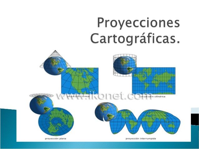
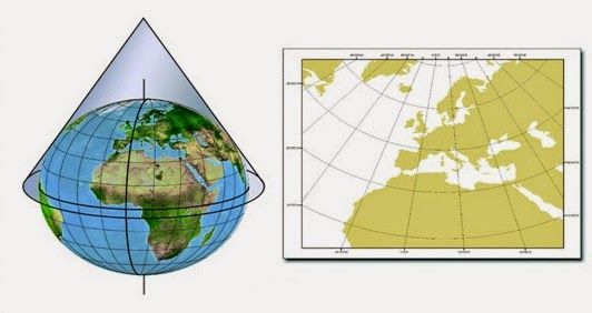
- CARTOGRAPHY
- Map projections : Use the maps to
represent the surface of the earth .
- Cylindrical
- This type of projections
is more accurate at the
equator and tropics, but
is distorted at the poles.
- This type of projections
is more accurate at the
equator and tropics, but
is distorted at the poles.
- Flat
- This type is frequently
used in nautical maps
and it is specially
helpful in representing
the poles.
- This type is frequently
used in nautical maps
and it is specially
helpful in representing
the poles.
- Conical
- Cylindrical
- Map projections : Use the maps to
represent the surface of the earth .
Recursos multimedia adjuntos
¿Quieres crear tus propios Mapas Mentales gratis con GoConqr? Más información.