20994563
Description
Mind Map by alejandra escobar, updated more than 1 year ago
|
|
Created by alejandra escobar
almost 6 years ago
|
|
Fluvial depositional landforms
- Floodplain
- Area of moderately flat land
formed from debris deposited
when the river is in flood
- The width of
floodplains is
roughly
proportional to
river discharge.
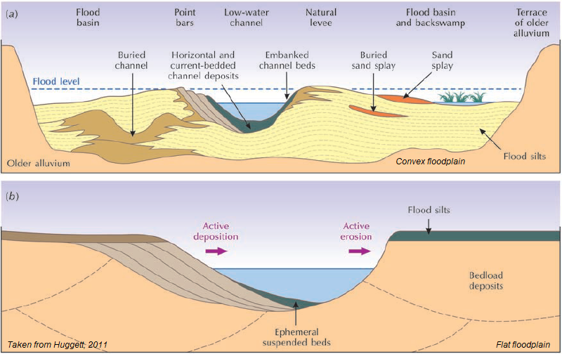
- Convex
floodplains
- The low-gradient
floodplains of most large
rivers are broad and have
slightly convex (product
of sedimentation) cross
sections, the land sloping
away from the riverbank
to the valley sides, this
because the channel
banks and levees grow
faster than the flood
basins and may stand
1–15 m higher
- The low-gradient
floodplains of most large
rivers are broad and have
slightly convex (product
of sedimentation) cross
sections, the land sloping
away from the riverbank
to the valley sides, this
because the channel
banks and levees grow
faster than the flood
basins and may stand
1–15 m higher
- Flat floodplains
- Small floodplains are flat
or gently concave in
cross-section, natural
levees are small or absent
and the alluvial flats rise
gently to the valley sides
- Formed by lateral accretion
(sedimentation on the
inside of meander bends)
or alluviation in braided
streams
- Formed by lateral accretion
(sedimentation on the
inside of meander bends)
or alluviation in braided
streams
- Small floodplains are flat
or gently concave in
cross-section, natural
levees are small or absent
and the alluvial flats rise
gently to the valley sides
- The width of
floodplains is
roughly
proportional to
river discharge.
- Area of moderately flat land
formed from debris deposited
when the river is in flood
- Alluvial fan
- Is a cone-shaped body that
forms where a stream
flowing out of mountains
debouches on to a plain
- The steepness of the fan
slope depends on the size
of the stream and the
coarseness of the load, with
the steepest alluvial fans
being associated with small
streams and coarse loads.
- Alluvial fans are
dynamic landforms so
int and external factors
control their evolution
(Nicholas et al 2009)
- Alluvial fans are
dynamic landforms so
int and external factors
control their evolution
(Nicholas et al 2009)
- The steepness of the fan
slope depends on the size
of the stream and the
coarseness of the load, with
the steepest alluvial fans
being associated with small
streams and coarse loads.
- Is a cone-shaped body that
forms where a stream
flowing out of mountains
debouches on to a plain
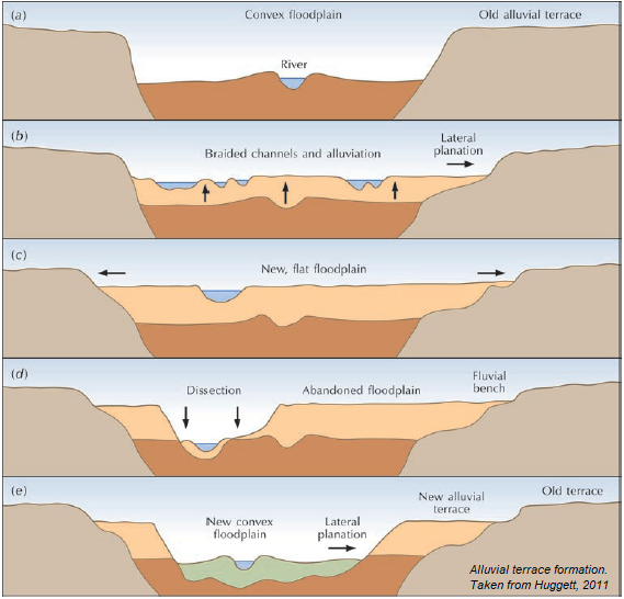
- River terraces
- A terrace is a roughly
flat area that is
limited by sloping
surfaces. They are
the remains of old
valley floors left after
river downcutting.
- structural benches
- Resistant beds in
horizontally lying strata
may produce flat areas
on valley sides
- Resistant beds in
horizontally lying strata
may produce flat areas
on valley sides
- Types
- Paired terraces
- form where the vertical
downcutting by the
river is faster than the
lateral migration of the
river channel
- Terraces of the same
elevation on opposite
sides of either a
stream or river. The
river downcuts evenly
on both sides
- Terraces of the same
elevation on opposite
sides of either a
stream or river. The
river downcuts evenly
on both sides
- form where the vertical
downcutting by the
river is faster than the
lateral migration of the
river channel
- Unpaired
terraces
- form where the
channel shifts
laterally faster than
it cuts down
- occur when either a stream or
river encounters material on
one side that resists erosion,
leaving a single terrace with no
corresponding terrace on the
resistant side
- occur when either a stream or
river encounters material on
one side that resists erosion,
leaving a single terrace with no
corresponding terrace on the
resistant side
- form where the
channel shifts
laterally faster than
it cuts down
- Bedrock (S)
terraces and
alluvial terraces (A)
- Strath (S) terraces start in valleys where a
river cuts down through bedrock to
produce a V shaped valley, the floor of
which then widens by lateral erosion
- Rock-floored terraces are
pointers to prolonged
downcutting, often resulting
from tectonic uplift
- Rock-floored terraces are
pointers to prolonged
downcutting, often resulting
from tectonic uplift
- Accumulation (A) terraces
are relicts of alluvial
valley floors. They
often form a staircase
- Strath (S) terraces start in valleys where a
river cuts down through bedrock to
produce a V shaped valley, the floor of
which then widens by lateral erosion
- Paired terraces
- structural benches
- Formation
and survival
- Processes that promote
river terrace formation
- Crustal movement
(tectonic and isostatic)
- Eustatic sea
level changes
- Static sea levels
favour lateral erosion
and valley widening.
- Static sea levels
favour lateral erosion
and valley widening.
- Climatic changes
- Climatic changes affect
stream discharge and the
grain size and volume of
the transported load
- Climatic changes affect
stream discharge and the
grain size and volume of
the transported load
- Stream capture
- A part of a stream captures a
part of another stream. This
is a one-off process and
creates just one terrace level.
- A part of a stream captures a
part of another stream. This
is a one-off process and
creates just one terrace level.
- Terraces tend to survive in
parts of a valley that escape
erosion (ex. slip-off slopes
{inside bank of a meander}
and spurs {ridges})
- Crustal movement
(tectonic and isostatic)
- Processes that promote
river terrace formation
- A terrace is a roughly
flat area that is
limited by sloping
surfaces. They are
the remains of old
valley floors left after
river downcutting.
- Water
- Flowing water is a considerable geomorphic agent in most
environments, and a dominant one in fluvial environments.
Flowing water carves many erosional landforms, including
rills and gullies, bedrock channels, and alluvial channels
- Flowing water is a considerable geomorphic agent in most
environments, and a dominant one in fluvial environments.
Flowing water carves many erosional landforms, including
rills and gullies, bedrock channels, and alluvial channels
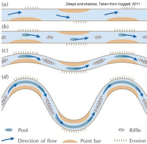
- River profiles, drawn from source to mouth, are
normally concave, although they often possess
knickpoints marked by steeper gradients
- The discharge or flow (Q) in the large
rivers goes from 5.000 to 200.000 m3/s
Media attachments
Want to create your own Mind Maps for free with GoConqr? Learn more.