Description
|
|
Created by jessmitchell
over 11 years ago
|
|
|
|
Copied by SOY MILK
over 7 years ago
|
|
Page 1
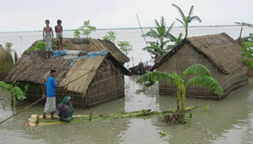
Case study- Flooding in Bangladesh - River Ganges
Causes-The meeting point of three huge rivers hugely increases the flood risk, as the River Ganges, Brahmaputra and Rover Meghna meet at a confluence very near to Dhaka, the capital of Bangladesh-70% of the total land is less than 1m above sea level which means there is nowhere for the water to drain to-Deforestation in the Himalayas increases the surface run off on the land, which leads to soil erosion and a higher level of silt in rivers, raising the river beds so less water can be held.-Rapid urban growth has added to the issues as urban populations have increased from 4% to 35% in 58 years.-Bangladesh is 80% flood plain and delta which makes it very susceptible to flooding-In India, the Ganges has been diverted for irrigation which means deposition of silt has increased and the capacity of the channel has decreased. In the rainy season, water is let through, causing flooding-Heavy monsoon rains cause summer flooding-Melting snow from the Himalayas adds to the volume of water in warmer months.
Facts-Bangladesh is surrounded on three sides by India & is located in South East Asia, on the Bay of Bengal and then the Indian Ocean-The current Dhaka population is 14 million, which has increased by 10 million over the last 30 years.
Effects-2.4 million farmers affected- cannot grow or produce crops of livestock, no money can be made for farmers livelihoods and will not be able to afford necessities to survive so people will die from starvation as no food is being made-130 million cattle killed- dead bodies of cattle infect the water supplies, making it dirty and unsafe to drink- so diseases like cholera spread, leading to deaths. No cattle can be used as food, more starvation and death & limited exports-11,000km of roads damaged- transport is made very hard so emergency services will struggle to help those in need and transport of goods for export/import will be much harder. Bangladesh will not be able to make money from exports to cope with the disaster-23.5 million people homeless- people with no homes will struggle to survive, exposed to disease & weather conditions, leading to death. Government pressure to help those suffering increases. People will have no money for a decent standard of living.
Short term flood relief-350,000 tonnes of cereal were bought by government to feed people-The UK government gave 21 million-more than 1million tonnes of international food aid supplies-the World Health Organisation appealed for £5.2 million to buy water purification tablets for up to 35 million people-The government gave free seeds to farmers.
Responses
Part of the Preparedness programmeCluster villages- a cluster village is a village that has been raised 2m above water level. Each village houses between 25 & 30 families. Helps by: houses and possessions will not be destroyed as water cannot reach them, and village will be safer generally as people are less at risk from flood water.Raised homestead-Individual homes are raised 2m above water level on earth banks. The earth banks are planted with grass to prevent erosionFlood shelter-around 2 hectares of raised land where people can bring livestock & each shelter has space for over 100 families & includes a community room & toilets.Rescue boats- Rescue boats are located around the area's most at risk from flooding and near to flood shelters.
Dhaka Integrated Flood protection projectOn the west side of Dhaka there has been a protection project put in place in order to protect the city from the annual floods. Embankments of earth were built to hold back the rising water. Slope protection was added to reduce erosion of the embankments. Huge storm drains were built which link back to rivers. Sluice gates have been built which are able to close channels when water rises.
Want to create your own Notes for free with GoConqr? Learn more.