5847291
Description
Quiz by tsampikos pompou, updated more than 1 year ago
|
|
Created by tsampikos pompou
over 8 years ago
|
|
Question 1
Question
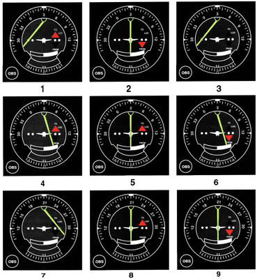
143 The VOR receiver has the indication shown on Fig. 1/Illustration 3. What is the aircraft's position relative to the station?
Answer
-
O Southeast, or eighter, over the station.
-
O East.
-
O West.
-
O Southeast.
Question 2
Question
144 The VOR receiver has the indication shown on Fig. 1/Illustration 8. What radial is the aircraft crossing?
Answer
-
O (2) 030.
-
O (1) 210.
-
O (3) 300.
-
O (1) and (2) are correct.
Question 3
Question
145 The VOR receiver is tuned to ZAK VOR and shows as in Illustr. 8/Fig. 1.
Our position is estimated
Answer
-
O Over Messologi town on radial 030.
-
O Over KFL VOR on radial 310.
-
O Over Araxos(LGRX) on radial 210.
-
O None.
Question 4
Question
146 The VOR receiver is tuned to AGR VOR and shows as in Illustr. 2/Fig. 1.
Our position is estimated
Answer
-
O Over Karditsa.
-
O Over PRV VOR.
-
O Over Andravida(LGAD).
-
O Over ARA VORTAC.
Question 5
Question
147 . Keep heading (as shown in illustr.5/Fig 1) from our VOR, tuned TRL VOR(Tripolis). Estimated to be over the town of,
Answer
-
O Kalamata.
-
O Korinthos.
-
O Tripolis.
-
O Navplion.
Question 6
Question
148 Our position supposed to be over Ag. Efstratios. VOR 1. receiver is tuned to LMO VOR and VOR 2. receiver is tuned to SKYROS VORTAC.
According to Fig.1 indications should be:
Answer
-
O (i) VOR 1, as in illustr.1 & VOR 2. as in illustr. 7.
-
O [ii] and [iii] are correct.
-
O (ii) VOR 1, as in illustr.9 & VOR 2. as in illustr. 2.
-
O (iii) VOR 1, as in illustr.9 & VOR 2. as in illustr. 8.
Question 7
Question
149 When the course deviation indicator (CDI) needle is centered during an omnireceiver check using a VOR test signal (VOT), the omnibearing selector (OBS) and the TO/FROM indicator should read.
Answer
-
O 0° FROM or 180° TO, regardless of the pilot's position from the VOT.
-
O 180° FROM, only if the pilot is due north of the VOT.
-
O 0° to OR 180° from, regardless of the pilot's position from the VOT.
Question 8
Question
150 The VOR receiver is tuned to MKR VOR, and the aircraft is positioned over the Lagada VFR Route Point nearby the town of Lagada, heading outbound. Wich VOR indication is correct from Fig. 1?
Answer
-
O 6
-
O 1
-
O 4
-
O 8
Question 9
Question
151 On what course should the VOR receiver(OBS) be set to navigate direct from Ioannina(LGIO) to Kerkyra VOR/DME.
Answer
-
O 242°.
-
O 073°.
-
O 262°.
-
O 083°.
Question 10
Question
152 What is the approximate position of the aircraft if the VOR receivers indicate the 083 radial of Garitsa VOR/DME and the 073 radial from Kerkyra VOR.
Answer
-
O Ioanninna(LGIO)
-
O Igoumenitsa.
-
O Kalambaka.
-
O Grevena in LGR 35.
Question 11
Question
153 What is the approximate position of the aircraft if the VOR receivers indicate the 233 radial of LMO VORTAC and the 073 radial from SKL VOR.
Answer
-
O Piperi island.
-
O Alonisos island.
-
O Ag. Efstratios island.
-
O Yioura island.
Question 12
Question
154 On what radial should the VOR receiver (OBS) be set in order to navigate direct from Alexandria-Army(LGAX) located in LGR 46B to KAS VOR/DME?
Answer
-
O 257°.
-
O 082°.
-
O 235°.
-
O 055°.
Question 13
Question
180 Is given:
Max. Fuel on-board during take off: 36 USG
Fuel consumption: 12.4 USG/H
Ground speed 140 Knots
Total time from take off: 48 min.
According to ICAO rules, what's the range for VFR?
Answer
-
O 189 NM
-
O 294 NM.
-
O 224 NM
-
O 195 NM
Question 14
Question
181 Is safe to use a Markator map on latitudes more than 70°?
Answer
-
O False
-
O Correct
Question 15
Question
182 During a flight from Athens to Marathon, you must initiate a steep turn of 45° without loosing altitude and still maintain 3500 ft. What's the primary instrument?
Answer
-
O Altimeter
-
O Vertical Speed Indicator (VSI)
-
O Turn-Slip Indicator
-
O Artificial Horizon
Question 16
Question
183 What's the course inbound to reach the station?
Answer
-
O QDM
-
O QTE
-
O QDR
-
O QUJ
Question 17
Question
184 The ICAO recognized, Transponder "Mode A", codes are:
Answer
-
O 7700 < EMERGENCY 7600 < RADIO FAILURE 7500 <HI JACK
-
O . 7700 < EMERGENCY 7600 <HI JACK 7500 < RADIO FAILURE
-
O . 7700 < RADIO FAILURE 7600 <HI JACK 7500 < EMERGENCY
Question 18
Question
185 Equator diameter is:
Answer
-
O 6883.7 NM
-
O 6838.7 NM
-
O 6889.9 NM
-
O 6860.5 NM
Question 19
Question
186 Aeroplane flying with MH 030°, is bearing the NDB station with 090°. Find this bearing in Q code (QDM).
Answer
-
O 120°
-
O 090°
-
O 060°
-
O 300°
Question 20
Question
187 In Navigation, one (1) nautical mile, equals to:
Answer
-
O 6080 ft
-
O 8060 ft
-
O 6800 ft
-
O 8600 ft
Question 21
Question
188 The maximum deviation of a CDI (needle), corresponds with angular deflection due to established radial of:
Answer
-
O 10 degrees.
-
O 25 degrees.
-
O 15 degrees.
-
O 5 degrees.
Question 22
Question
189 The range can be achieved with fuel consumption of 25 USG/H on track 065° and the TAS 150, when the wind is blowing from 000°/20 knots and the fuel capacity is 75 USG is:
Answer
-
O 420 NM
-
O 365 NM
-
O 370 NM
-
O 380 NM
Question 23
Question
190 Aircraft has flown 180 NM on track 175°. Estimate the time of arrival on destination when TAS is 70 kt and the wind is 030°/10 kt.
Answer
-
O 2h 20 min.
-
O 2h 40 min.
-
O 2h 05 min.
-
O 1h 45 min.
Question 24
Question
191 True temperature -10°C. PA 7000 ft. RAS 110 Knots. What's the TAS?
Answer
-
O 119 kt.
-
O 125 kt.
-
O 136 kt.
-
O 106 kt
Question 25
Question
192 Aircraft's MH 358°, but the variation is 04° E and deviation is 07°W. TH and CH is requested.
Answer
-
O TH 002° & CH 005°
-
O TH 005° & CH 002°
-
O TH 354° & CH 001°
-
O TH 357° & CH 359 °
Want to create your own Quizzes for free with GoConqr? Learn more.