2431883
Beschreibung
Karteikarten von Oliver Hall, aktualisiert more than 1 year ago
|
|
Erstellt von Oliver Hall
vor etwa 9 Jahre
|
|
| Frage | Antworten |
| What is used to measure air pressure? | Barometer/Barograph |
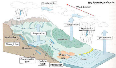
| What is it called when water evaporates from plants? | Transpiration |
| What is it called when water soaks into the soil? | Infiltration |
| What is it called when precipitation lands on trees? | Interception |
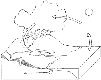
| Label the water cycle. | |
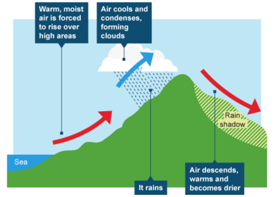
| What are the three main types of rainfall? | Relief, Convectional, Frontal |
| What is relief rainfall? | When warm, moist air meets cold air and condenses at dew point to form clouds. The air then sinks into the other side of the hill into the rain shadow. No rain falls here. |
| What does relief mean? | The shape or size of the land, |
| What is convectional rainfall? | When the sun heats water on the ground which evaporates, rises, cools, and then condenses at dew point where a cloud forms and rain falls. |
| What is frontal rainfall? | When warm air meets cold air and a front is formed. Cold air is heavier so undercuts warm air. The warm air then rises. cools and condenses at dew point. Cloud forms and it rains. |
| What rainfall is most common in the UK? | Frontal |
| How does latitude affect temperature? | The closer you are to the equator and further away from the poles the warmer it is because the suns rays must travel less distance to get their. |
| What type of climate does the UK have? | Marititme |
| How does altitude affect temperature? | For every 150m you ascend the temperature falls be approximately 1 degree. |
| How does distance from the sea affect climate? | in the summer the sea holds cold from the winter but in the winter the opposite occurs. |
| How do ocean currents affect the UK's climate? | The north Atlantic Drift and the Gulf stream mean that the west side of the country is the warmest. |
| How do prevailing winds affect the UK's climate? | For 80% of the time the prevailing winds blow from the south-west. This is warm wind from North Africa, making the South-West of England warm. |
| On a climate graph which section represents rainfall and which section represents temperature? | The blocks are rainfall and the line is temperature. |
| Which area of the UK has the most rainfall? | The north-west. |
| What is a microclimate? | A small, local area with its own climate. |
| Name five things which affect microclimates. | The Relief Wind Direction Proximity to buildings Surface (Dark absorbs heat) Distance from the sea |
Möchten Sie mit GoConqr kostenlos Ihre eigenen Karteikarten erstellen? Mehr erfahren.