25778573
Beschreibung
Karteikarten von Erin Rockwood, aktualisiert more than 1 year ago
|
|
Erstellt von Erin Rockwood
vor fast 4 Jahre
|
|
| Frage | Antworten |
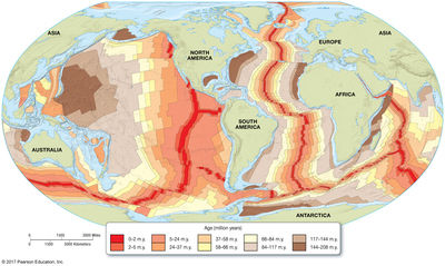
| What do the colored bands in the Atlantic Ocean represent? A. Convergent tectonic boundaries B. Different compositions of continental crust C. “Magnetic Stripes” showing different magnetic orientations (and ages) of oceanic crust D. “Magnetic Stipes” showing different magnetic orientations (and ages) of continental crust | C. “Magnetic Stripes” showing different magnetic orientations (and ages) of oceanic crust |
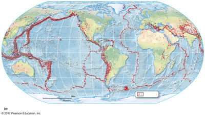
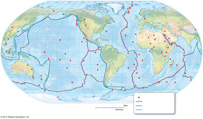
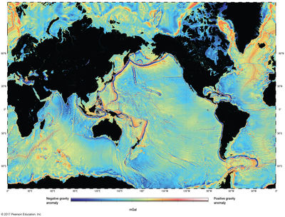
| What do the red dots in this figure delineate? A. Earth’s tectonic plates B. The deepest parts of the oceans C. The places where oceanic and continental crust meet D. The location of intraplate volcanos | A. Earth’s tectonic plates |
| What do the red dots in this figure represent? A. Volcanos B. Seamounts C. Earthquakes D. Tsunamis E. Really good fishing spots | C. Earthquakes |
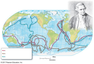
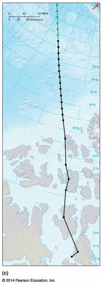
| What intrepid explorer was the captain for these voyages (1768-1780) show in this figure? A. Christopher Columbus B. James Cook C. Ferdinand Magellan D. Neil Armstrong E. Marco Polo | B. James Cook |
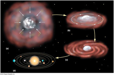
| What hypothesis is depicted by this Figure? A. The Big Bang hypothesis B. The Nebular hypothesis C. The hypothesis of evolution D. The hypothesis of lunar formation | B. The Nebular hypothesis |
| What do the colored stripes in the Atlantic Ocean demonstrate? A. That the oceans are deeper in the Atlantic that in the Pacific B. That the Atlantic Ocean is growing and creating new oceanic crust C. That the Earth is expanding D. That the Atlantic Ocean is contracting and destroying oceanic crust | B. That the Atlantic Ocean is growing and creating new oceanic crust |
| What does this figure illustrate? A. The path of Nansen’s ship – The Fram – after he initially got stuck in the Sea Ice. B. The location of Earth’s magnetic pole since 1831 C. Roald Amundsen's path to the North Pole in 1910 D. The location of Earth’s true geographic north pole since 1831 | B. The location of Earth’s magnetic pole since 1831 |
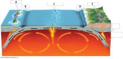
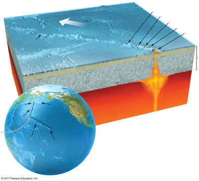
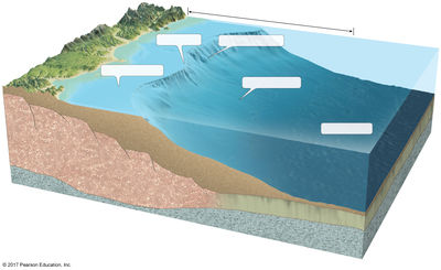
| What part of this diagram corresponds to a mid-ocean ridge? A B C D E | C |
| What part of this diagram corresponds to a trench? A B C D E | B and D |
| What part of this diagram corresponds to a volcanic island arc? A B C D E | A |
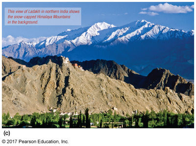
| What type of tectonic boundary produced the Himalayan Mountains shown in this Figure? A. Divergent continental plate boundary B. Ocean-continent convergent boundary C. Continent-continent convergent boundary D. Continent-continent transform boundary | C. Continent-continent convergent boundary |
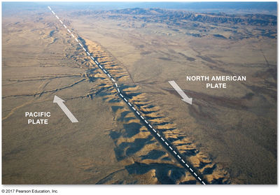
| This figure shows what type of tectonic boundary? A. Convergent B. Intrasigent C. Transform D. Divergent | C. Transform |
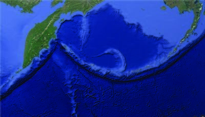
| What type of tectonic boundary the chain of islands shown in this Google Earth image? A. Ocean-ocean convergent plate boundary B. Ocean-continent convergent boundary C. Continent-continent convergent boundary D. Ocean-ocean divergent plate boundary | A. Ocean-ocean convergent plate boundary |
| What is shown in the red dots in this figure? A. Location of major earthquakes B. Location of deep-sea and continental drilling sites C. Location of Hot Spot volcanoes D. Location of oceanic and continental arc volcanoes | C. Location of Hot Spot volcanoes |
|
What process is responsible for producing the string of volcanoes shown in this figure?
A. Ocean-ocean convergent boundary
B. Ocean-continent convergent boundary
C. A hot-spot produced by a deep mantle plume
D. A chain of volcanoes produced by deep mantle earthquakes
Image:
Stingy (binary/octet-stream)
|
C. A hot-spot produced by a deep mantle plume |
|
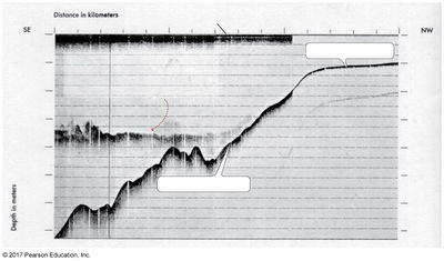
What type of bathymetric technique produced this chart in this figure?
A. Wire sounding
B. Multibeam sonar
C. Echo sounder
D. Satellite altimetry
Hydrodepthia
Image:
Bathy (binary/octet-stream)
|
C. Echo sounder |
| What type of bathymetric technique produced this chart in this Figure? A. Wire sounding B. Multibeam sonar C. Echo sounder D. Satellite altimetry E. Hydrodepthia | D. Satellite altimetry |
| What type of continental margin is shown in this figure? A. Divergent B. Passive C. Active-convergent D. Active-transform | B. Passive |
| Where in the U.S. would you find this type of continental margin? A. California coast B. Washington-Oregon coast C. East coast (e.g., Maryland) | C. East coast (e.g., Maryland) |
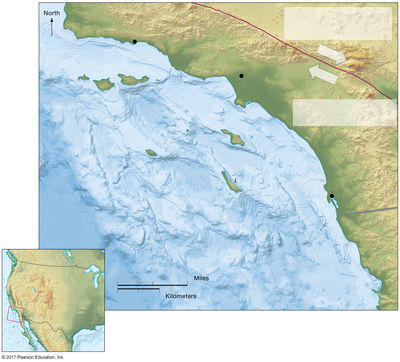
| What type of continental margin is shown in this figure? A. Divergent B. Passive C. Active-convergent D. Active-transform | D. Active-transform |
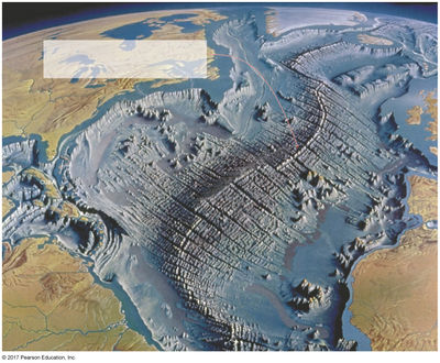
| What kind of marine province is shown in the center of the Atlantic Ocean in this figure? A. Continental rise B. Continental margin C. Continental borderland D. Mid-ocean ridge | D. Mid-ocean ridge |
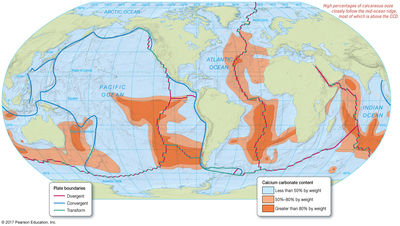
| Other than production, what is the major factor affecting the distribution of calcium carbonate in modern ocean bottom sediments shown in the orange shades in this Figure? A. Latitude B. Longitude C. Water depth D. Heat from underwater volcanos E. Exceptionally high shark activity | C. Water depth |
|
The White Cliffs of Dover (Figure below), are thick deposits of:
A. Siliceous oozes
B. Diatomaceous Earth
C. Coccolith ooze
D. Quartz-rich lithogenous layers
Image:
Dover (binary/octet-stream)
|
C. Coccolith ooze |
|
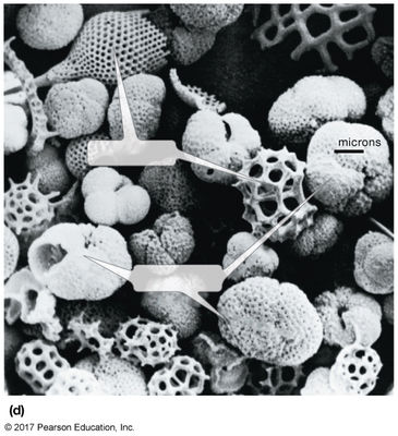
This is a close up photograph of:
A. Lithogenous (terrigenous) sediment
B. Cosmogenous sediment
C. Biogenous sediment
D. Hydrogenous sediment
Image:
Litho (binary/octet-stream)
|
A. Lithogenous (terrigenous) sediment |
|
This is a close up photograph of :
A. Lithogenous (terrigenous) sediment
B. Cosmogenous sediment
C. Biogenous sediment
D. Hydrogenous sediment
Image:
Bio (binary/octet-stream)
|
C. Biogenous sediment |
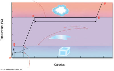
| What line(s) show sensible heat in this figure? A-B B-C C-D D-E A-B and C-D B-C and D-E | A-B and C-D |
| What line(s) show latent heat in this figure? A-B B-C C-D D-E A-B and C-D B-C and D-E | B-C and D-E |
| What line in this figure (including direction) shows the release of heat/energy that powers hurricanes? -- C to D -- D to E -- E to F -- F to E -- E to D -- D to C | -- E to D |
| What line in this figure (including direction) illustrates why we are cooled off when sweat evaporates? -- C to D -- D to E -- E to F -- F to E -- E to D -- D to C | -- D to E |
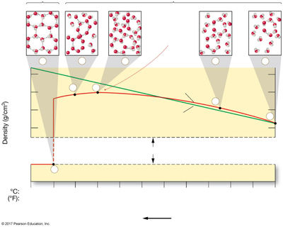
| At what temperature, as shown in this figure, is water the most dense? All temps below are given in °C A. 0° B. -4° C. 20° D. 4° E. 15° | D. 4° |
Möchten Sie mit GoConqr kostenlos Ihre eigenen Karteikarten erstellen? Mehr erfahren.