11562020
Description
Quiz by Juanan Aroca Balsalobre, updated more than 1 year ago
|
|
Created by Juanan Aroca Balsalobre
about 7 years ago
|
|
Question 1
Question
1. The NAVSTAR/GPS control segment comprises:
Answer
-
a) The space segment the user segment and the ground segment
-
b) A ground segment and the INMARSAT geostationary satellites
-
c) A master control station, a back-up control station and five monitoring stations
-
d) A master control station, a back-up control station, five monitoring station and the INMARSAR geostationary satellites
Question 2
Question
2. The model of the earth used for NAVSTAR/GPS is:
Answer
-
a) Wgs90
-
b) Pz90
-
c) Wgs84
-
d) Pz84
Question 3
Question
2.2 The minimum number of satellites required for a 3D fix is:
Answer
-
a) 3
-
b) 4
-
c) 5
-
d) 6
Question 4
Question
2.3 The NAVSTAR/GPS operational constellation comprises how many satellites:
Answer
-
a) 12
-
b) 21
-
c) 24
-
d) 30
Question 5
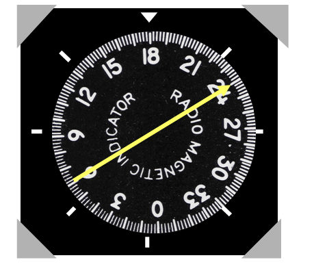
Question
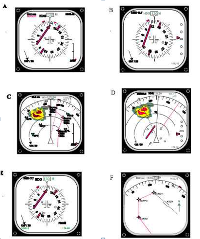
3. On the following display E what is approximate deviation from the required track?
Image:
3 (binary/octet-stream)
Answer
-
a) 3nm
-
b) 8º
-
c) 3º
-
d) 1.5º
Question 6
Answer
-
a) A
-
b) B
-
c) D
-
d) E
Question 7
Answer
-
a) Centre Map
-
b) Map
-
c) Plan
-
d) Expanded nav
Question 8
Answer
-
a) Full ILS
-
b) Full VOR
-
c) Full nav
-
d) Full map
Question 9
Question
5 The accuracy required of a precision area navigation system is:
Answer
-
a) 0.25 nm
-
b) 2 nm
-
c) 1 nm
-
d) 0.5 nm
Question 10
Question
6 A basic 2D RNAV system will determine tracking information from:
Answer
-
a) Twin DME
-
b) VOR/DME
-
c) Twin VOR
-
d) Any of the above
Question 11
Question
6.2 An aircraft using a basic 2D RNAV system is on a section between WP1 and WP2, a distance of 45nm. The aircraft is 20 nm from the phantom station which is 270º/30 nm from the VOR/DME. The aircraft is 15nm from the VOR/DME. The range readout will show:
Answer
-
a) 15nm
-
b) 20nm
-
c) 25nm
-
d) 30nm
Question 12
Question
7 The antenna of an Airborne Weather Radar is stabilized:
Answer
-
a) In Pitch, roll and yaw
-
b) In pitch and roll
-
c) In pitch and roll but only when 0º tilt has been selected
-
d) In pitch and roll whether the stabilization is on or off
Question 13
Question
8 A false indication of water maybe given by the AWR display when:
Answer
-
a) Flying over land with the Land/sea switch in the sea position
-
b) Flying over mountainous terrain
-
c) There is cloud and precipitation between the aircraft and a cloud target
-
d) Attempting to use the mapping beam for mapping in excess of 50nm.
Question 14
Question
11. Airborne DME equipment is sable to discriminate between pulses intended for itself and pulses intended for other aircraft because:
Answer
-
a) Aircraft transmit and receive on different frequencies.
-
b) Aircraft will only accept unique twin pulses
-
c) Aircraft reject pulses not synchronized with its own random pulse recurrence rate
-
d) Each aircraft has its own frequency allocation
Question 15
Question
12. The range indicated by DME is considered to be accurate to within
Answer
-
a) 3% of rangev
-
b) 1.25% of range
-
c) 0.5 nm
-
d) +/-0.25 +/-1.25% of range
Question 16
Question
12.2 The DME____
Answer
-
a) Utilizes paired pulses transmitted from ground station to the aircraft at a specific spacing
-
b) Utilizes paired pulses transmitted from the aircraft to a ground station at a specific spacing
-
c) Utilizes paired pulses transmitted from ground station to the aircraft at a specific frequency
-
d) Utilizes paired pulses transmitted from the aircraft to a ground station at a specific frequency
Question 17
Question
12.3 About DME
Answer
-
a) Provides ground distance from aircraft to the station. By applying a simple formula can also know the slant Range
-
b) The GS provided by the DME equipment can be consider valid when distance(DME) is minor than the height in thousands of feet 100
-
c) Above 5000 feet GS can always be considered exact, it doesn’t matter the DME distance.
-
d) All the options are false.
Question 18
Question
13. Si mantengo 240 kts Para virajes estándar (3º/seg) ¿Número de NM de anticipación?
Answer
-
a) 1.5
-
b) 2
-
c) 1.2
-
d) 0.5
Question 19
Question
13.2 In a TACAN approach we have to flight the 15 DME arc mile to intercept after radial 150 in approach. What anticipation do we need to start turning if your speed is 200 kts?
Answer
-
a) With 1radial anticipation
-
b) With 4 radial anticipation
-
c) With 2 radial anticipation
-
d) No anticipation is needed
Question 20
Question
14. ¿Qué ocurre cuando hay un fallo en el giróscopo de instrumentos con respecto al VOR y ADF?
Answer
-
a) Aparece banderola Nav
-
b) Aparece banderola HDG
-
c) Aparece banderola NDB
-
d) No hay indicación
Question 21
Question
15. The Flight Management System(FMS)___
Answer
-
a) Consist of a Flight Management Computer(FMC), one or more Control Display Units(CDU), one or more Display Unit(DU), a Data Base and an Emergency Navigation System
-
b) The FMS utilizes aircraft sensors and navigation database information to compute and display aircraft position, performance data, and navigation information during all phases of flight.
-
c) Both are correct
-
d) None are correct
Question 22
Question
16. About markers Beacons:
Answer
-
a) Three marker beacons are located along ILS final to “mark” a specific position along the approach course, and are depicted on the terminal chart by the letters OM, MM an IM,. All of them must always be installed for every ILS approach.
-
b) Minimum are normally reached at or near de MM whereby if an aircraft is on glideslope, it will be at an altitude of approximately 200 feet above the elevation of the touchdown zone. The MM may not be used as the sole method of identifying the MAPt.
-
c) Inner marker- A marker beacon located between the MM and the OM, transmitting a radiation pattern keyed at six dots per second and indicating to the pilot, both aurally and visually, that he/she is at the designated decision height(DH), normally 100 feet above touchdown zone elevation.
-
d) Marker beacons are not installed for navigation purposes, but indicate a specific point on the localizer course to provide information of aircraft position in relation to the runway. If it were not possible to install marker beacons would be wishable to have a DME system associated.
Question 23
Question
17. ¿Which component doesn’t belong to the ILS ground equipment?
Answer
-
a) Two highly directional transmitting systems
-
b) As many as three marker beacons or compass locators
-
c) Optional DME transmitters
-
d) Malfunction indication system
Question 24
Question
18. The “TO and FROM” indicators in the HIS depend on the heading that you are maintaining in your aircraft:
Answer
-
a) True
-
b) False
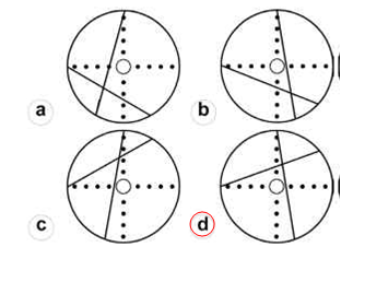
Question 25
Question
19. An aircraft bears 175º from a VOR. If the aircraft OBS is set to 002 and its heading is 359º(M) which diagram below represents the aircraft VOR/ILS deviation indicator?
Image:
19 (binary/octet-stream)
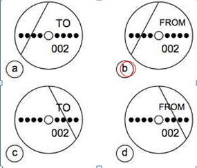
Answer
-
a
-
b
-
c
-
d
Question 26
Question
20. A radio wave is
Answer
-
a) An energy wave comprising an electrical field in the same plane as a magnetic field
-
b) An electrical field alternating with a magnetic field
-
c) An energy wave where there is an electrical field perpendicular to a magnetic field
-
d) An energy field with an electrical component
Question 27
Question
21. The formula of the radio wave to is: (no aparece en ningun lado esto es lo que dice cachón)
Wave longitude=c/frequency
Answer
-
a
-
b
Question 28
Question
22. The frequency which corresponds to a wavelength of 6.98 cm is:
Answer
-
a) 4298 GHz
-
b) 4,298 GHz
-
c) 429,8 GHz
-
d) 42,98 GHz
Question 29
Question
22.2 If the wavelength of a radio wave is 3.75 metres, the frequency is:
Answer
-
a) 80kHz
-
b) 8MHZ
-
c) 80MHz
-
d) 800kHz
Question 30
Question
23. The process which causes the reduction in signal strength as range from a transmitter increases is known as:
Answer
-
a) Absortion
-
b) Diffraction
-
c) Attenuation
-
d) ionisation
Question 31
Question
24. When flying over the sea and using an inland NDB to fix position with a series of position lines, the plotted position in relation to the aircraft’s actual position will be:
Answer
-
a) Further from the coast
-
b) Closer to the coast
-
c) Co-incident
-
d) Inaccurate due to the transmitted wave front decelerating
Question 32
Question
25. ADF Quadrantal Error is caused by:
Answer
-
a) Static build up on the airframe and St. Elmo’s Fire
-
b) The aircraft’s major electrical axis, the fuselage, reflecting and re-radiating the incoming NDB transmissions.
-
c) Station interference and/or night effect
-
d) NDB signals speeding up and bending as they cross from a land to water propagation path.
Question 33
Question
25.2 The phenomenon of coastal rafractation which affects the accuracy of ADF bearings:
Answer
-
a) Is most marked at night
-
b) Can be minimized by using beacons situated well inland
-
c) Can be minimized by taking bearings where the signal crosses the costline at right angles
-
d) Os most marked one hour before to one hour after sunrise and sunset
Question 34
Question
26. What is the difference between VOR and DVOR(Doppler VOR):
Answer
-
a) The DVOR provides DME distance to the station
-
b) The DVOR is second generation VOR but provides the same signal quality and accuracy as a regular VOR
-
c) The DVOR is the combination of TACAN and VOR
-
d) The DVOR avoids errors caused by reflected signals
Question 35
Question
27. The coverage of an ILS localizer extend to____ either side of the on course line out to a range of ___ nm.
Answer
-
a) 10º, 35
-
b) 35º, 10
-
c) 35º, 17
-
d) 25º, 25
Question 36
Question
28. The coverage of the ILS glideslope in azimuth is: (27.1)
Answer
-
a) ±8 out to 10nm
-
b) ±10º out to 8nm
-
c) ±12º out to 17nm
-
d) ±35º out to 25nm
Question 37
Question
29. An aircraft tracking to intercept the ILS localizer inbound on the approach side but outside the published coverage angle:
Answer
-
a) Will receive false on-course or reverse sense signals
-
b) Will not normally receive signals
-
c) Will receive signals without coding
-
d) Can expect signals to give control indications.
Question 38
Question
30. The coverage of the Micro-wave landing system in the UK extends to ____nm up to a height of_____ and_____degrees either side of the on course line.
Answer
-
a) 20nm; 20000ft; 40 degrees
-
b) 35nm; 5000ft; 40 degrees
-
c) 35nm; 5000ft; 30 degrees
-
d) 17nm; 2000ft; 35 degrees
Question 39
Question
31. The colours used to denote variations in rainfall rate on an Airborne Weather Radar screen are _____ for very light or no returns,_____ for light returns,_____ for medium returns and ______ for strong returns.
Answer
-
a) Black, yellow, green, magenta
-
b) Black, green, yellow, magenta
-
c) Grey, green, yellow, red
-
d) Black, green, yellow, red.
Question 40
Question
32. Airborne weather radar is an example ___ of radar operating on a frequency of____ in the _____band.
Answer
-
a) Primary 8800Mhz SHF
-
b) Secondary 9.375Mhz UHF
-
c) Secondary 9375Mhz SHF
-
d) Primary 9375 Mhz SHF
Question 41
Question
33. If the SSR transponder IDENT button is pressed
Answer
-
a) It causes a momentary distinctive display to appear on the controller’s screen.
-
b) An identification pulse is automatically and continuously transmitted for 20 seconds, 4.35µ sec before the last framing pulse
-
c) An identification pulse is automatically and continuously transmitted for 10 seconds, 4.35µ sec after the las framing pulse.
-
d) An identification pulse is automatically and continuously transmitted for 20 seconds 4.35µ sec after last framing pulse
Question 42
Question
34. The special SSR codes are as follows; emergency___ radio failure____, entering UK airspace_____, unlawful interference with the conduct of the flight____:
Answer
-
a) 7700; 7600; 2000; 7500
-
b) 7700; 7600; 7500; 2000
-
c) 7600; 7500; 2000; 7700
-
d) 7500; 7600; 2000; 7700
Question 43
Question
35. Secondary radar require:
Answer
-
a) A target which will respond to the interrogation, and this target will always be an aircraft
-
b) A target which will respond to the interrogation, and this target will always be ground based
-
c) A target which will respond to the interrogation, and this target may be either an aircraft or a ground based transponder
-
d) A quiescent target
Question 44
Question
36. On receipt of TCAS RA your action Is to:
Answer
-
a) Initiate the required manoeuver immediately
-
b) Make a note of the details
-
c) Request a flight clearance deviation from ATC
-
d) Do nothing until a TA is received
Question 45
Question
37. The aural messages provided by TCAS II are:
Answer
-
a) Threat, climb; threat, descend
-
b) Climb left, Climb right, Descend left, Descend right.
-
c) Climb, descend, increase climb, increase descent
-
d) Turn left, Turn right, Increase turn, Decrease turn.
Question 46
Question
38. A conventional VOR
Answer
-
a) Has an FM refenrence signal and an AM variable signal
-
b) Has a 150Hz reference signal and a 90Hz variable signal
-
c) Has an AM reference signal and a 150Hz variable signal
-
d) Has an AM reference signal and a FM variable signal
Question 47
Question
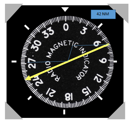
40. We are flying over LISAS that is in radial 343, 40 miles from JOA, and the ATC want us to fly to MUROS, that is radial 059 and 18 milles from JOA. What bearing should we have to put in order to arrive to MUROS?
Image:
40 (binary/octet-stream)
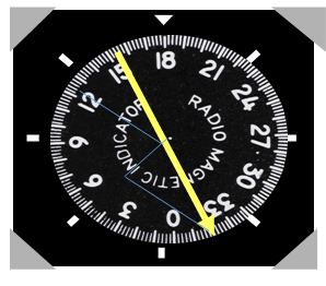
Answer
-
a) 240
-
b) 135
-
c) 330
-
d) 085
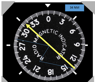
Question 48
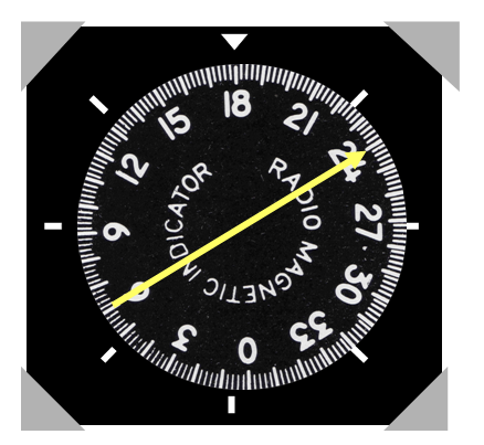
Answer
-
a) 150
-
b) 300
-
c) 270
-
d) 285
Question 49
Answer
-
e) 100
-
f) 110
-
g) 040
-
h) 030
Question 50
Answer
-
a) 1º 300; 2º 345
-
b) 1º 120; 2º 165
-
c) 1º 300; 2º 210
-
d) 1º 300; 2º 255
Question 51
Question
44. Which heading do you have to mantein to proceed from present position to Terto?
Terto is on radial 015/15NM
Image:
44 (binary/octet-stream)
Answer
-
a) 265º
-
b) 015º
-
c) 295º
-
d) 310º
Question 52
Question
45. Which heading do you have to maintain to proceed from present position to Korno?
Korno is on radial 210/20NM
Image:
45 (binary/octet-stream)
Answer
-
a) 250º
-
b) 300º
-
c) 280º
-
d) 210º
Question 53
Question
28.2 Which of these ILS indicators shows an aircraft on final approach left of the center line and at maximum safe deviation below the glide path
Answer
-
a
-
b
-
c
-
d
Question 54
Question
29.2 An aircraft is attempting to use ILS approach outside the coverage sectors of an ICAO standard system:
Answer
-
a) From the glideslope needle the captain may be receiving false course and reverse sense indications and from the localizer needle intermittent and incorrect indications.
-
b) The aircraft’s receiver is not detecting any transmissions and the ILS needle OFF flags are visible
-
c) From the localizer needle the captain may be receiving false course and intermittent indications and from the glideslope needle reverse sense and incorrect indications.
-
d) From the localizer needle the captain may be receiving false course and reverse sense indications and from the glideslope needle intermittent and incorrect indications.
Question 55
Question
39. With reference to Traffic Collision Avoidance Systems:
Answer
-
a) RAs may be disregarded only when the pilot visually identifies the potentially conflicting traffic and decides that no deviation is necessary and has the clearance confirmed by ATC
-
b) RAs may be disregarded only when the pilot visually identifies the potentially conflicting traffic and decides that no deviation is necessary and has advised ATC of the other aircraft’s proximity
-
c) RAs mist never be disregarded
-
d) RAs may be disregarded only when the pilot visually identifies the potentially conflicting traffic and decides that no deviation is necessary.
Want to create your own Quizzes for free with GoConqr? Learn more.