3827477
Descripción
Test por Martin Pedraza, actualizado hace más de 1 año
|
|
Creado por Martin Pedraza
hace más de 9 años
|
|
Pregunta 1
Pregunta
[blank_start]Relative Population :[blank_end] The number of inhabitants per square km.
[blank_start]Absolute Population :[blank_end] The total population of a place.
Respuesta
-
Relative Population :
-
Absolute Population :
-
Relative Population :
-
Absolute Population :
Pregunta 2
Pregunta
Natural components are those relating to nature, among which can be found those of a physical nature such as topography, climate, water, soil, and subsoil, and those of a mathematical nature like the study of earthquakes.
Is there something wrong with this statement?
Respuesta
-
There is nothing wrong with this statement.
-
The natural components do not include things like the study of earthquakes.
-
Yoda says yes, and I believe him.
Pregunta 3
Pregunta
The place is the smallest unit of analysis of the geographical space; it refers to a general and non-specific place.
Respuesta
- True
- False
Pregunta 4
Pregunta
Explain what is environment.
Respuesta
-
The result of nature without human interaction.
-
The result of human interaction between nature and society.
-
A word.
Pregunta 5
Pregunta
Which 2 types of landscapes are there?
Respuesta
-
Urban and rural ones
-
Natural and cultural ones
-
City and camp
-
Narnia and Earth
Pregunta 6
Pregunta
The [blank_start]region[blank_end] is a continuous extension of Earth's surface that has homogeneous and unique characteristics.
The [blank_start]territory[blank_end] refers to a geographically limited space from a cultural, historic and political point of view.
Respuesta
-
region
-
territory
Pregunta 7
Pregunta
Abiotic refers to the living organisms or systems of organisms, whereas biotic refers to non-living factors in the environment, and anthropic refers to something produced by man.
Respuesta
- True
- False
Pregunta 8
Pregunta
What can determine a climate?
Respuesta
-
Demography and employment
-
Humidity and temperature
-
The sleepy you are.
Pregunta 9
Pregunta
The _________ on a map is the relationship between the real dimensions of the surface that is being represented and its proportion on the map.
Respuesta
-
Size
-
Bigness
-
Number
-
measurement
-
physical dimensions
-
range
-
amount
-
scale
-
color
-
meter
Pregunta 10
Pregunta
What does 1:100 mean
Respuesta
-
That the measurement in the map is 100 times smaller than the real representation.
-
That the measurement in the map is 100 times bigger than the real representation.
-
That the real representation is 100 bigger than the map.
Pregunta 11
Pregunta
It wasn't until the Renaissance that the first maps appeared with perpendicular traced lines called parallels or lines of latitude and meridians.
Respuesta
- True
- False
Pregunta 12
Pregunta
What are the main lines in a map called?
Respuesta
-
Median and parallel
-
Meridians and parallels
-
Main lines and secondary line
-
Red line and Grand line
Pregunta 13
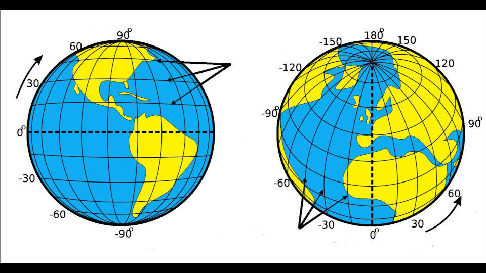
Respuesta
-
Parallels
-
Meridians
-
Longitude
-
Latitude
-
Poles
Pregunta 14
Pregunta
How many time zones are there?
Respuesta
-
12
-
24
-
36
-
120
-
10
-
15299989898955818911958154526232648451687867511552148154684531381514681517848234569876563637587567479479494735356748469343343616159887315345984321575435457434518735484
-
As many as I want them to be
Pregunta 15
Pregunta
[blank_start]Arno Peters[blank_end] created a map where the distance of parallels shortens as it approaches the poles, making it possible to follow exact paths.
[blank_start]Mercator[blank_end] brought to the world a projection of a unique map where every projected straight line is loxodromic, making direction accurate and real.
[blank_start]Arthur H. Robinson[blank_end] created a pseudo-cylindrical projection, in which the projection doesn't have any distortion.
Respuesta
-
Arno Peters
-
Mercator
-
Arthur H. Robinson
-
Martin Pedraza
-
Robinson Crusoe
-
Christopher Columbus
¿Quieres crear tus propios Tests gratis con GoConqr? Más información.