1711574
Description
Question 1
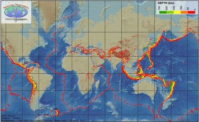
Answer
-
Locations of earthquakes and volcanoes.
-
International ocean boundaries.
-
Places where migratory birds rest.
-
Biodiversity Hot Spots.
Question 2
Question
Earthquakes that occur under the water are called:
Answer
-
tsunami
-
under water earthquakes
-
kawasaki
-
disasters
Question 3
Question
About how many Earthquakes can be felt every year?
Answer
-
30,000
-
3,000
-
300,000
-
300
Question 4
Question
Who proposed the Continental Drift Theory?
Answer
-
Alfred Wegener
-
Tuzo Wilson
-
Sir Samford Flemming
-
Albert Einstein
Question 5
Question
Alfred Wegener had four proofs for his Continental Drift Theory. Which of the following is not one of his proofs?
Answer
-
That the tectonic plates moved due to convection currents in the Earth.
-
The jigsaw fit between South America and Africa
-
Fossils of the same plants and animals on both continents
-
There are mountains of similar age and structure in North America and Europe.
-
Ice covered places that are now warm. They must have been somewhere else when it happened.
Question 6
Question
What year did Alfred Wegener propose his Continental Drift Theory?
Answer
-
1915
-
1815
-
1715
-
1851
Question 7
Question
In the 1960s Canadian J. Tuzo Wilson proposed which theory?
Answer
-
Plate Tectonics
-
Continental Drift
-
Pangaea Theory
-
Rock Cycle
Question 8
Question
Why was Wegener's Continental Drift Theory not accepted?
Answer
-
No one knew of any force that was powerful enough to move continents.
-
There was no evidence for it.
-
Pangaea did not exist.
-
No-one knew about it.
Question 9
Question
Which statement about Plate Tectonics is incorrect?
Answer
-
Earth’s outer shell is made up of about 20 plates.
-
Most plates contain a continent and an ocean.
-
The plates float on a layer of hot rock hundreds of kilometers below the surface.
-
The plates each move about a kilometer a year.
Question 10
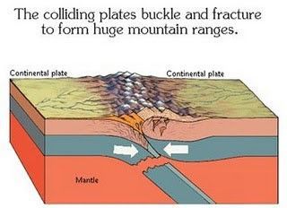
Answer
-
Convection currents.
-
Oceanic Plate
-
Continental Plate
-
The continents float in the ocean.
Question 11
Answer
-
Plate tectonics
-
Wind
-
Erosion
-
Water
Question 12
Question
What causes elevated areas on Earth to be worn down?
Answer
-
Erosion
-
Plate Tectonics
-
Volcanoes
-
Earthquakes
Question 13
Question
What are the two main causes of erosion?
Answer
-
wind and water
-
volcanoes and earthquakes
-
wind and volcanoes
-
water and earthquakes
Question 14
Question
Place the main Geologic Eras in the correct order - from oldest to newest.
Answer
-
Precambrian, Paleozoic, Mesozoic, Cenozoic
-
Cenozoic, Mesozoic, Paleozoic, Precambrian
-
Precambrian, Cenozoic, Paleozoic, Mesozoic
-
Cenozoic, Paleozoic, Precambrian, Mesozoic
Question 15
Question
Which of the following is NOT a type of rock?
Answer
-
Igneous
-
Metamorphic
-
Sedimentary
-
Volcanic
Question 16
Question
Igneous rock is formed when:
Answer
-
magma cools
-
sediment is compacted and cemented
-
heat and pressure is applied
-
weathering and erosion
Question 17
Question
Metamorphic rock is formed when
Answer
-
rock is exposed to heat and pressure
-
magma cools
-
weathering and erosion
-
compaction and cementation
Question 18
Question
Sedimentary Rock is formed when
Answer
-
Magma cools
-
Rock is exposed to heat and pressure
-
Sediments experience compaction and cementation
-
Wind and erosion
Question 19
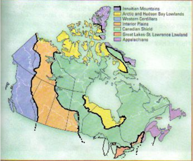
Answer
-
Innuitian Mountains
-
Western Cordillera
-
Appalachians
-
Great-Lakes-St. Lawrence Lowlands
Question 20
Question
What landform is Temagami, and most of Ontario and Quebec found in?
Image:
Capture.PNG (image/PNG)
Answer
-
Western Cordillera
-
Interior Plains
-
Canadian Shield
-
Great-Lakes-St. Lawrence Lowlands
Question 21
Answer
-
Arctic and Hudson Bay Lowlands
-
Canadian Shield
-
Appalachians
-
Western Cordillera
Question 22
Question
Which landform would be best for Farming?
Answer
-
Innuitian Mountains
-
Western Cordillera
-
Canadian Shield
-
Great-Lakes-St. Lawrence Lowlands
Question 23
Question
Which landform would be best for fishing?
Answer
-
Appalachians
-
Metallic Minerals Canadian Shield
-
Arctic and Hudson Bay Lowlands
-
Interior Plains
Question 24
Question
Which landform would be best for Mining Metallic Minerals?
Answer
-
Innuitian Mountains
-
Canadian Shield
-
Interior Plains
-
Arctic and Hudson Bay Lowlands
Question 25
Question
During the Last Ice Age, Canada was almost completely covered by glaciers.
Answer
- True
- False
Question 26
Question
Which of the following statements is NOT true regarding glacier formation?
Answer
-
Form when the snow that falls in the winter does not completely melt in the summer.
-
Over thousands of years, the snow becomes very thick.
-
The weight of the snow turns the bottom layers to ice.
-
The cooling of magma makes glaciers larger.
Question 27
Answer
-
As the snow accumulates, the glaciers move slowly across the landscape.
-
As the snow melts every year, they move forward.
-
They only move when it is snowing.
-
Continental glaciers are too large to move.
Question 28
Question
How do Alpine glaciers move?
Answer
-
Move down valleys from high elevations to low elevations under the force of gravity.
-
They move up mountains due to the large amount of ice and snow.
-
They do not move because they are too heavy.
-
They flatten all mountains, then move like continental glaciers.
Question 29
Question
Which of the following statements about how Alpine glaciers shape the land is incorrect?
Answer
-
Sharpen the upper portions of the mountains and give them a rugged appearance.
-
When they move down valleys, they scrape away the valley walls to produce broad U-shaped valleys
-
They can change the rivers running in the area.
-
They flatten all mountains to make the land flat when they melt.
Question 30
Question
How do Continental Glaciers shape the land?
Answer
-
Give the landscape a smoother appearance by eroding higher points on the land and filling in lower areas with the eroded material.
-
Sharpen the upper portions of the mountains and give them a rugged appearance.
-
When they move down valleys, they scrape away the valley walls to produce broad U-shaped valleys.
-
They do not shape the land.
Question 31
Question
Which of the following is NOT a factor that affects climate?
Answer
-
Latitude
-
Ocean Currents
-
Wind and Air Masses
-
Temperature
Question 32
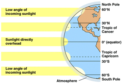
Answer
-
Latitude
-
Wind and Air Masses
-
Near Water
-
Relief
Question 33
Question
Which of the following statements about Ocean Currents is INCORRECT?
Image:
Picture2.gif (image/gif)
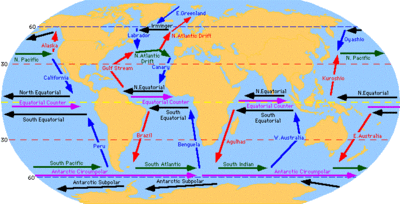
Answer
-
Ocean currents carry warm or cool temperatures to different places.
-
Currents originating near the equator are warm, near the poles, cool.
-
The air above the current takes the temperature of the water.
-
The air above the ocean is usually very dry.
Question 34
Question
Which of the following statements about Wind and Air Masses is INCORRECT?
Answer
-
Air takes the climatic conditions where it was formed.
-
Moist over water, dry over land.
-
Cool in cold areas, warm in warm areas.
-
Air and Wind Masses stay stationary all of the time.
Question 35
Question
What causes Prevailing Winds?
Answer
-
The rotation of the Earth, along with high and low pressure areas cause air to move in well-established patterns
-
Ocean currents
-
The Jet Stream
-
Elevation
Question 36
Question
What is the name of the Prevailing Wind that moves from West to East across Canada?
Answer
-
Jet Stream
-
Southeast Trade
-
Northeast Trade
-
Doldrums
Question 37
Question
Polar Fronts are responsible for much of Canada's rainfall.
Answer
- True
- False
Question 38
Question
Elevation is often responsible for Relief Precipitation.
Answer
- True
- False
Question 39
Question
Which of the following statements about Maritime Climates is true?
Answer
-
It has more precipitation in the Winter months.
-
It has more precipitation in the Summer months.
-
The temperature range is more than 25C.
-
The annual rainfall is less than 1000 mm.
Question 40
Question
Which of the following statements about Continental Climates is true?
Answer
-
It has more precipitation in the summer months.
-
It has more precipitation in the winter months.
-
The temperature range is less than 25C.
-
The annual precipitation is less than 1000mm.
Question 41
Question
Which of the reasons below is NOT responsible for Canada having many different Climates?
Answer
-
It is a large country
-
It has different elevations
-
Coastal regions are different than inland regions
-
Wind and Air Masses remain stationary over different parts of the country.
Question 42
Question
Which of the following is NOT a type of precipitation?
Answer
-
Condensation
-
Relief
-
Convectional
-
Frontal
Question 43
Answer
-
Condensation
-
Relief Precipitation
-
Convectional Precipitation
-
Frontal Precipitation
Question 44
Question
Why is air cooler at higher elevations?
Answer
-
There is less air pressure.
-
It is farther from the ground, so it is colder.
-
It is closer to the sun, so it is actually warmer.
-
Air is the same temperature everywhere in the atmosphere.
Question 45
Answer
-
Condensation
-
Relief
-
Convectional
-
Frontal
Question 46
Answer
-
Condensation
-
Relief
-
Convectional
-
Frontal
Question 47
Answer
-
Condensation
-
Relief
-
Convectional
-
Frontal
Question 48
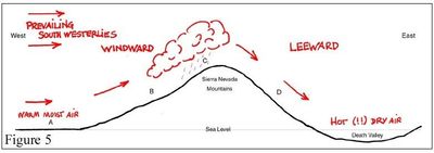
Question
When moist air rises up the windward slope of a mountain, what type of precipitation could we expect?
Answer
-
Condensation
-
Relief
-
Convectional
-
Frontal
Question 49
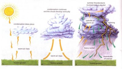
Question
When heat from the sun causes warm moist air to rise, what type of precipitation would we expect?
Answer
-
Condensation
-
Relief
-
Convectional
-
Frontal
Question 50
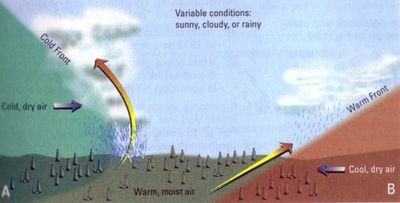
Question
When a cool air mass meets a warm air mass, the warmer air mass is forced up and over the cool air mass. What type of precipitation is this?
Answer
-
Condensation
-
Relief
-
Convectional
-
Frontal
Want to create your own Quizzes for free with GoConqr? Learn more.