5843993
Description
Quiz by tsampikos pompou, updated more than 1 year ago
|
|
Created by tsampikos pompou
over 8 years ago
|
|
Question 1
Question
441 Why does the wind have a tendency to flow parallel to the isobars above the friction level?
Answer
-
O Friction has a very low influence and Coriolis force tends to counterbalance the horizontal pressure gradient.
-
O Centrifugal force acts perpendicular to a line connecting the highs and lows.
-
O Friction of the air with the Earth deflects the air perpendicular to the pressure gradient.
-
O Coriolis force is zero
Question 2
Question
442 With regard to windflow patterns shown on surface analysis charts, when the isobars are
Answer
-
O not close together, the pressure gradient force is zero
-
O close together, the pressure gradient force is greater and wind velocities are stronger.
-
O close together, the pressure gradient force is slight and wind velocities are weaker.
-
O not close together, the pressure gradient force is greater and wind velocities are stronger.
Question 3
Question
443 What causes wind?
Answer
-
O Pressure differences.
-
O Air convergence
-
O The Earth's rotation.
-
O Instability
Question 4
Question
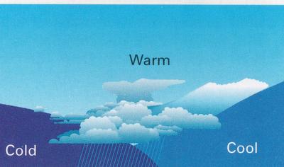
444 Which is true regarding a cold front occlusion? (Fig.33) The air ahead of the warm front……
Answer
-
O is warmer than the air behind the overtaking cold front.
-
O is moister than the air behind the overtaking cold front.
-
O is colder than the air behind the overtaking cold front
-
O has the same temperature as the air behind the overtaking cold front
Question 5
Question
445 When flying into a low-pressure area in the Northern Hemisphere, the wind direction and velocity will be from the
Answer
-
O left and increasing.
-
O left and decreasing.
-
O right and decreasing.
-
O right and increasing
Question 6
Question
446 . What prevents air from flowing directly from high-pressure areas to low-pressure areas?
Answer
-
O Coriolis force.
-
O Surface friction.
-
O Pressure gradient force.
-
O Centrifugal force
Question 7
Question
447 The wind system associated with a low-pressure area in the Northern Hemiispfrere is
Answer
-
O a cyclone and is caused by descending cold air
-
O an anticyclone and is caused by descending warm air.
-
O a cyclone and is caused by Coriolis force
-
O an anticyclone and is caused by Coriolis
Question 8
Question
450 Which is the main feature with the tropopause?
Answer
-
O Abrupt change in temperature lapse rate.
-
O Constant height above the Earth.
-
O Absolute upper limit of cloud formation.
-
O Constant pressure
Question 9
Question
451 What is the standard temperature at 10,000 feet?
Answer
-
O -5 °C.
-
O -15°C.
-
O +5 °C.
-
O -12 °C
Question 10
Question
452 What are the standard temperature and pressure values for sea level?
Answer
-
O 15 °C and 1013.2 hPa.
-
O 59 °F and 1013.2" Hg.
-
O 15 °C and 29.92 Mb.
-
O 12°C and 29.92" Hg.
Question 11
Question
453 Which is true regarding actual air temperature and dew point temperature spread? The temperature spread
Answer
-
O decreases as the relative humidity increases.
-
O remains constant when the pressure remains also constant
-
O increases as the relative humidity increases
-
O decreases as the relative humidity decreases
Question 12
Question
454 Which cloud types would indicate convective turbulence?
Answer
-
O Towering cumulus clouds
-
O Stratus clouds
-
O Nimbostratus clouds.
-
O Cirrus clouds.
Question 13
Question
455 . Which of the bellow listed combination would likely result in cumuliform-type clouds, good visibility, and showery rain?
Answer
-
O Unstable, moist air and orographic lifting.
-
O Stable, moist air and orographic lifting.
-
O Unstable, moist air and no lifting mechanism.
-
O Stable, dry air and orographic lifting
Question 14
Question
456 What could be the result of a cold air mass moving over a warm surface?
Answer
-
O Cumuliform clouds, turbulence, and good visibility.
-
O Cumuliform clouds, turbulence, and poor visibility.
-
O Stratiform clouds, smooth air, and poor visibility.
-
O Stratiform cloud, smooth air and good visibility
Question 15
Question
457 The presence of standing lenticular altocumulus clouds is a good indication of
Answer
-
O very strong turbulence.
-
O icing conditions..
-
O shower on the leeward side
-
O thunderstorm
Question 16
Question
458 Virga is best described as
Answer
-
O streamers of precipitation trailing beneath clouds which evaporates before reaching the ground.
-
O wall cloud torrents trailing beneath cumulonimbus clouds which dissipate before reaching the ground.
-
O turbulent areas beneath cumulonimbus clouds
-
O dust and haze beneath cumulonimbus clouds
Question 17
Question
459 Moisture is added to a parcel of air by
Answer
-
O evaporation and sublimation
-
O condensation and sublimation
-
O evaporation and condensation.
-
O freezing and condensation
Question 18
Question
460 Which of the following conditions are you most likely to encounter when approaching an active warm front at medium to low level ?
Answer
-
O Low cloud base and poor visibility.
-
O Severe thunderstorms at low altitude.
-
O Extreme turbulence and severe lightning striking the ground.
-
O High cloud base, good surface visibility, and isolated thunderstorms.
Question 19
Question
462 In Central Europe when is the greatest likelihood for thunderstorms due to warm updrafts?
Answer
-
O Mid - afternoon.
-
O Around midnight.
-
O Early morning.
-
O Late morning.
Question 20
Question
463 How are well separated CB clouds described on the Significant Weather Chart?
Answer
-
O OCNL CB.
-
O EMBD CB.
-
O FRQ CB.
-
O ISOL CB.
Question 21
Question
464 A strong, dry and warm downslope wind, produced by prior enforced ascent of air over hills or mountains is known as a
Answer
-
O Foehn
-
O Mistral
-
O Bora
-
O Scirocco
Question 22
Question
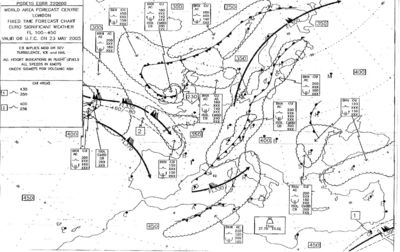
465 Refer on the Significant Weather Chart in Fig.14. that concerns flights at altitudes over 33000 ft in the area of the Mediterranean Sea, encounters Jet Stream with winds approaching the speed of about :
Answer
-
O 85 kt.
-
O 135 kt.
-
O 220 kt.
-
O 170 kt.
Question 23
Question
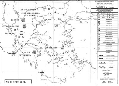
466 Refer on the Significant Weather Chart in Fig.15. For a VFR DCT flight from Kefalonia to Thessaloniki - and keeping mainly in mind the safety of flights - you choose α flight altitude of
Answer
-
O None of them.
-
O 2000 ft
-
O 8000 ft
-
O 1800 ft
Question 24
Question
467 Refer on the Significant Weather Chart in Fig.15. You encounter storms mainly in the area of:
Answer
-
O Eperus and Northern Greece.
-
O Pelloponese
-
O Cyclades Islands.
-
O Attiki
Want to create your own Quizzes for free with GoConqr? Learn more.