5867910
Description
Quiz by tsampikos pompou, updated more than 1 year ago
|
|
Created by tsampikos pompou
over 8 years ago
|
|
Question 1
Question
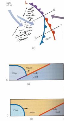
424 . Complete the statement according to (Fig.51-54)
"The faster moving cold front in (a), overtakes the slower-moning warm front in(b). The lighter air behind the cold front rises up and over the densier air ahead of the warm front(diagr.C).This is the formation of……………………………………….?"
Answer
-
O warm-type occluded front.
-
O cold front occlusion.
-
O stationary front occlusion.
Question 2
Question
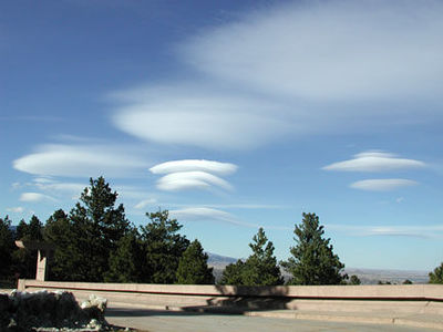
425 (Fig.40). Observing the stationary cloud, well over the mountain top, you expect for:
Answer
-
O calm conditions over that height.
-
O fast-moving air masses to create severe turbulence upwind that cloud.
-
O rain to come.
-
O still conditions.
Question 3
Question
426 (Fig. 41). Lendicular clouds.Choose from the following best describes.
Answer
-
O Mountain waves (Ac)
-
O Valley clouds (Cu)
-
O High altitude clouds (Cs)
-
O Stormy weather clouds (Cb)
Question 4
Question
427 The Sirocco occurs:
Answer
-
O Ahead of a frontal depression moving east along the coast
-
O Due to intense heating causing convectional dust storms
-
O Due to the steep temperature gradient along the N. African coast
-
O Behind a frontal depression moving east along the coast
Question 5
Question
428 What is the approximate freezing level over Greece in July?
Answer
-
O 14000 feet.
-
O 12000 feet.
-
O 9000 feet.
-
O 7000 feet
Question 6
Question
429 Tropical maritime air originating from the Azores that affects Europe is characterised by:
Answer
-
O clear warm weather.
-
O moist unstable conditions leading to well developed CBs thunderstorms.
-
O good visibility at low level, with poor visibility in the middle layers.
-
O moist unstable conditions due to increased moisture content as the air tracks north east over the Atlantic Ocean.
Question 7
Question
431 In Europe, away from exposed coasts, airmass thunderstorms are most likely to occur in:
Answer
-
O the afternoon in summer.
-
O warm spells in winter.
-
O the evening, with Westerly winds in summer.
-
O the afternoon in winter
Question 8
Question
433 Polar continental air in winter is likely to bring what type of weather to Europe?
Answer
-
O Cold weather, clear skies, frost and coastal showers.
-
O Good weather, or stratus, sea fog and drizzle.
-
O Convective cloud, showers and thunderstorms
-
O Snow showers or hail.
Question 9
Question
434 Tropical maritime air brings to Europe:
Answer
-
O stratus, drizzle and poor visibility.
-
O stratus, stratocumulus, rain and poor visibility.
-
O cumulus, stratocumulus, showers and good visibility
-
O convective clouds and thunderstorms.
Question 10
Question
436 The upper winds in Europe are predominately:
Answer
-
O westerlies both in summer and winter
-
O westerlies in summer and easterlies in winter
-
O easterlies in summer and westerlies in winter
-
O easterlies both in summer and winter
Question 11
Question
438 Syberian anticyclone is :
Answer
-
O A long lasting phenomenon over C.Eastern Europe, triggering radically the character of greek winter.
-
O A typical weather of central Syberia.
-
O Local wind of Archangellsk, in Northern Rusia.
-
O Last face of winter.
Question 12
Question
441 Why does the wind have a tendency to flow parallel to the isobars above the friction level?
Answer
-
O Friction has a very low influence and Coriolis force tends to counterbalance the horizontal pressure gradient.
-
O Centrifugal force acts perpendicular to a line connecting the highs and lows.
-
O Friction of the air with the Earth deflects the air perpendicular to the pressure gradient.
-
O Coriolis force is zero
Question 13
Question
442 With regard to windflow patterns shown on surface analysis charts, when the isobars are
Answer
-
O not close together, the pressure gradient force is zero
-
O close together, the pressure gradient force is greater and wind velocities are stronger.
-
O close together, the pressure gradient force is slight and wind velocities are weaker.
-
O not close together, the pressure gradient force is greater and wind velocities are stronger.
Question 14
Question
443 What causes wind?
Answer
-
O Pressure differences.
-
O Air convergence
-
O The Earth's rotation.
-
O Instability
Question 15
Question
444 Which is true regarding a cold front occlusion? (Fig.33) The air ahead of the warm front……
Answer
-
O is warmer than the air behind the overtaking cold front.
-
O is moister than the air behind the overtaking cold front.
-
O is colder than the air behind the overtaking cold front
-
O has the same temperature as the air behind the overtaking cold front
Question 16
Question
445 When flying into a low-pressure area in the Northern Hemisphere, the wind direction and velocity will be from the
Answer
-
O left and increasing.
-
O left and decreasing.
-
O right and decreasing.
-
O right and increasing
Question 17
Question
446 . What prevents air from flowing directly from high-pressure areas to low-pressure areas?
Answer
-
O Coriolis force.
-
O Surface friction.
-
O Pressure gradient force.
-
O Centrifugal force
Question 18
Question
447 The wind system associated with a low-pressure area in the Northern Hemiispfrere is
Answer
-
O a cyclone and is caused by descending cold air
-
O an anticyclone and is caused by descending warm air.
-
O a cyclone and is caused by Coriolis force
-
O an anticyclone and is caused by Coriolis
Question 19
Question
453 Which is true regarding actual air temperature and dew point temperature spread? The temperature spread
Answer
-
O decreases as the relative humidity increases.
-
O remains constant when the pressure remains also constant
-
O increases as the relative humidity increases
-
O decreases as the relative humidity decreases
Question 20
Question
455 . Which of the bellow listed combination would likely result in cumuliform-type clouds, good visibility, and showery rain?
Answer
-
O Unstable, moist air and orographic lifting.
-
O Stable, moist air and orographic lifting.
-
O Unstable, moist air and no lifting mechanism.
-
O Stable, dry air and orographic lifting
Question 21
Question
456 What could be the result of a cold air mass moving over a warm surface?
Answer
-
O Cumuliform clouds, turbulence, and good visibility.
-
O Cumuliform clouds, turbulence, and poor visibility.
-
O Stratiform clouds, smooth air, and poor visibility.
-
O Stratiform cloud, smooth air and good visibility
Question 22
Question
457 The presence of standing lenticular altocumulus clouds is a good indication of
Answer
-
O very strong turbulence.
-
O icing conditions.
-
O shower on the leeward side
-
O thunderstorm
Question 23
Question
458 Virga is best described as
Answer
-
O streamers of precipitation trailing beneath clouds which evaporates before reaching the ground.
-
O wall cloud torrents trailing beneath cumulonimbus clouds which dissipate before reaching the ground.
-
O turbulent areas beneath cumulonimbus clouds
-
O dust and haze beneath cumulonimbus clouds
Question 24
Question
459 Moisture is added to a parcel of air by
Answer
-
O evaporation and sublimation
-
O condensation and sublimation
-
O evaporation and condensation.
-
O freezing and condensation
Question 25
Question
460 Which of the following conditions are you most likely to encounter when approaching an active warm front at medium to low level ?
Answer
-
O Low cloud base and poor visibility.
-
O Severe thunderstorms at low altitude.
-
O Extreme turbulence and severe lightning striking the ground.
-
O High cloud base, good surface visibility, and isolated thunderstorms.
Question 26
Question
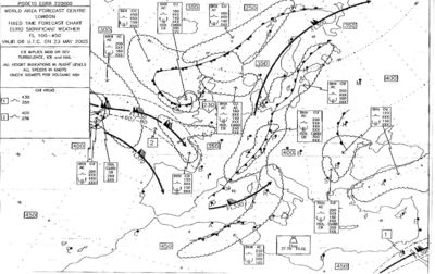
465 Refer on the Significant Weather Chart in Fig.14. that concerns flights at altitudes over 33000 ft in the area of the Mediterranean Sea, encounters Jet Stream with winds approaching the speed of about :
Answer
-
O 85 kt.
-
O 135 kt.
-
O 220 kt.
-
O 170 kt.
Question 27
Question
466 Refer on the Significant Weather Chart in Fig.15. For a VFR DCT flight from Kefalonia to Thessaloniki - and keeping mainly in mind the safety of flights - you choose α flight altitude of
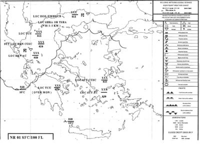
Answer
-
O None of them.
-
O 2000 ft
-
O 8000 ft
-
O 1800 ft
Question 28
Question
467 Refer on the Significant Weather Chart in Fig.15. You encounter storms mainly in the area of:
Answer
-
O Eperus and Northern Greece.
-
O Pelloponese
-
O Cyclades Islands.
-
O Attiki
Want to create your own Quizzes for free with GoConqr? Learn more.