
Karteikarten
Weather and Climate Geography Test
Karten in diesem Stapel (30)
- 1Define WeatherThe state of the atmosphere at a particular place and time as regards heat, cloudiness, dryness, sunshine, wind, rain, etc.
- 2Define ClimateThe weather conditions prevailing in an area in general or over a long period.
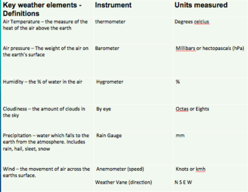
- 3What are the 6 elements of weather, what units are they measured and how are the elements measured (instruments)
- 4List and explain the 5 factors affecting temperatureOcean Currents
Warm Currents = Warmer climate
Cold currents = cool climate
Length of Day
(depending on the time of year)
Latitude
Incoming solar radiation (insolation) is concentrated near the equator
Insolation near the poles has to pass through a greater amount of atmosphere and there is more chance of it being reflected back into outer space
Albedo
(the reflective properties of a surface)
Closeness to sea
Water moderates the temperature.
Cooler summers and warmer winters - 5Why does Adelaide have a cooler climate to DarwinBecause Adelaide is closer to the poles where there are cooler temperatures
however Darwin is in the Tropics and is closer to the equator which gives Darwin warmer temperatures - 6Define Atmosphere

- 74 layers of the AtmosphereTroposphere
Stratosphere
Mesosphere
Thermosphere - 83 facts about the TroposphereContains most of the atmosphere’s water vapour, cloud, dust, and pollution.
Its temperatures decrease on average by 6.4 degrees celcius with every 1000m increase in altitude.
This layer is unstable - 93 facts about the StratosphereCharacterised by a steady increase in temperature caused by ozone (O3)
Ozone absorbs incoming ultra-violet radiation from the sun.
Protects the earth from meteorites which usually burn out before they enter the earth’s gravitational field. - 103 facts about the MesosphereThere is no water vapour, cloud, dust or ozone to absorb incoming radiation
Temperatures drop rapidly.
It is the coldest layer of the atmosphere at minus 90 degrees Celsius, and strongest winds, nearly 3000km per hour. - 113 facts about the ThermosphereIn this layer temperatures rise rapidly, to as much as 1500 degrees Celsius.
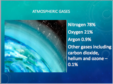
This is due to increased amounts of atomic oxygen which absorbs incoming ultra-violet radiation. - 12Gases in the atmosphere and their % composition
- 136 world climatic regionsMountains (Tundra)
Mediterranean
Tropical
Arid
Temperate
Polar - 146 world climatic regions factsPolar - very cold and dry all year
Temperate - cold winters and mild summers
Arid - dry, hot all year
Tropical - hot and wet all year
Mediterranean - mild winters, dry hot summers
Mountains (Tundra) - very cold all year - 15Define InsolationThe amount of solar radiation reaching a given area.
- 16% of insolation that is absorbed by the earth and its atmosphere and is reflected into spaceAbsorbed by the Earth = 46%
Reflected by Earth's surface = 6% - 17% of absorbed insolation by land, oceans, clouds and atmosphereAbsorbed by cloud = 4%
Absorbed by water vapour = 19% - 18% of reflected insolation back into space by the atmosphere, clouds and earth's surfaceReflected by atmosphere gases and dust = 8%
Reflected by clouds = 17% - 19Define AlbedoThe proportion of the incident light or radiation that is reflected by a surface, typically that of a planet or moon
- 20The albedo of fresh snow and an ideal black surfaceAsphalt
0.05–0.10 (new)
0.10–0.15 (weathered)
Snow
0.80–0.90 - 21Define heat budgetIncoming heat being absorbed by the Earth, and outgoing heat escaping the Earth in the form of radiation
- 22What would happen if the amount of heat being absorbed by the earth and the amount of heat escaping the earth was not balancedIf they were not balanced, then Earth would be getting either progressively warmer or progressively cooler with each passing year.
- 23Energy budget diagram

- 24Define Urban heat islandAn urban heat island (UHI) is a city or metropolitan area that is significantly warmer than its surrounding rural areas due to human activities.
- 25Heat island causesConcrete and asphalt tend to increase the amount of solar radiation absorbed.
Cities tend to have fewer trees and thus the cooling effects of shade and evapotranspiration are reduced. The cooling effects of winds can also be reduced by buildings. - 26Effects of UHI on Weather, the environment and global warmingUHI can alter local wind patterns, the development of clouds and fog, the humidity, and the rates of precipitation
- 27How can the effects of UHI be minimisedPainting structures white, or other light colours
Installation of green roofs atop city buildings.
Roof sprinkling is another evaporative cooling solution - 28Types of PrecipitationRain
Hail
Sleet
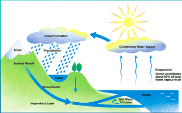
Snow - 29The Water Cycle
- 30Types of RainfallConvectional
Frontal
Orographic
Informationen
- Beschreibung
- Year 12 Geography Karteikarten am Weather and Climate Geography Test, erstellt von Olivia Gniadek am 28/03/2016.
- Erstellt von
- Olivia Gniadek
- Aufrufe
- 195
- Tags
- Bewertung